Givors geodata
Givors (Auvergne-Rhône-Alpes) is a populated place; located in France in Europe/Paris (GMT+2) time zone. With population of 18,198 people, there are 522 cities with bigger population in this country. Compared to other cities in France, 72.7% of cities are located further ↑North; 74.6% of cities are located further ←West and 57.6% of cities have lower elevation than Givors. Note1
Administrative division(s):
- Level 1: Auvergne-Rhône-Alpes
- Level 2: Département du Rhône
- Level 3: Arrondissement de Lyon
- Level 4: Givors


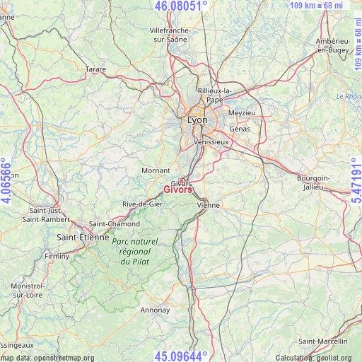
Givors GPS coordinates[2]
45° 35' 26.268" North, 4° 46' 7.608" East
| Map corner | latitude | longitude |
|---|---|---|
| Upper-left | 46.08051°, | 4.06566° |
| Center: | 45.59063°, | 4.76878° |
| Lower-right: | 45.09644°, | 5.47191° |
| Map W x H: | 109.4×109.4 km | = 68×68mi |
| max Lat: | 51.07786° ⇑72.7% North |
| Givors: | 45.59063° |
| min Lat: | ⇓27.3% South 41.3874° |
| min Long | Givors | max Long |
| -5.08615° | 4.76878° | 9.52242° |
| W 74.6%⇐ | ⇒25.4% E |
Elevation
Elevation of Givors is 160 m = 525 ft, and this is 33.7 m = 111 ft below average elevation for this country.
| Max E: |
2333 m = 7654 ft | 42.4% |
| Avg. | 193.7 m = 635 ft | |
| Givors | 160 m = 525 ft | |
Min E: |
-1 m = -3 ft | 57.6% |
See also: France elevation on elevation.city.
Geographical zone
Givors is located in North temperate zone (between Tropic of Cancer and the Arctic Circle). Distance of this North polar circle is 2332 km =1449 mi to North.| Distance of | km | miles | from Givors |
|---|---|---|---|
| North Pole | 4937.9 | 3068.3 | to North |
| Arctic Circle | 2332 | 1449 | to North |
| Tropic Cancer | 2463.3 | 1530.6 | to South |
| Equator | 5069.2 | 3149.9 | to South |


Nearby cities:
15 places around Givors: (largest is in red/bold)
• Charly
6.8 km =4.2 mi,  17°
17°
• Chassagny
3.4 km =2.1 mi,  302°
302°
• Chasse-sur-Rhône
3.5 km =2.2 mi,  112°
112°
• Communay
5.4 km =3.4 mi,  73°
73°
• Grigny
2.6 km =1.6 mi,  39°
39°
• Loire-sur-Rhône
5.1 km =3.2 mi,  151°
151°
• Millery
4.7 km =2.9 mi,  12°
12°
• Montagny
4.5 km =2.8 mi,  338°
338°
• Saint-Andéol-le-Château
5.8 km =3.6 mi,  264°
264°
• Saint-Romain-en-Gier
5.6 km =3.5 mi,  239°
239°
• Seyssuel
6.8 km =4.2 mi,  121°
121°
• Sérézin-du-Rhône
6 km =3.7 mi,  45°
45°
• Taluyers
6.6 km =4.1 mi,  326°
326°
• Ternay
3.5 km =2.2 mi, 68°
• Échalas
6 km =3.7 mi,  224°
224°
Sources, notices
• [Note1] Compared only with cities in France existing in our database
• [Src1] Map data: © OpenStreetMap contributors (CC-BY-SA)
• [Src2] Other city data from geonames.org with taken over terms of usage.
• [Src3] Geographical zone / Annual Mean Temperature by Robert A. Rohde @ Wikipedia
