Saint-Agrève geodata
Saint-Agrève (Auvergne-Rhône-Alpes) is a populated place; located in France in Europe/Paris (GMT+2) time zone. With population of 2,834 people, there are 3440 cities with bigger population in this country. Compared to other cities in France, 79.6% of cities are located further ↑North; 71.4% of cities are located further ←West and 99.3% of cities have lower elevation than Saint-Agrève. Note1
Administrative division(s):
- Level 1: Auvergne-Rhône-Alpes
- Level 2: Département de l'Ardèche
- Level 3: Arrondissement de Tournon-sur-Rhône
- Level 4: Saint-Agrève


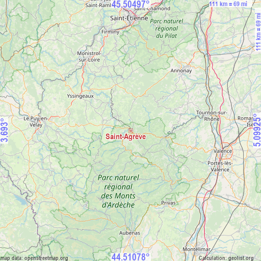
Saint-Agrève GPS coordinates[2]
45° 0' 36.108" North, 4° 23' 46.032" East
| Map corner | latitude | longitude |
|---|---|---|
| Upper-left | 45.50497°, | 3.693° |
| Center: | 45.01003°, | 4.39612° |
| Lower-right: | 44.51078°, | 5.09925° |
| Map W x H: | 110.5×110.5 km | = 68.7×68.7mi |
| max Lat: | 51.07786° ⇑79.6% North |
| Saint-Agrève: | 45.01003° |
| min Lat: | ⇓20.4% South 41.3874° |
| min Long | Saint-Agrève | max Long |
| -5.08615° | 4.39612° | 9.52242° |
| W 71.4%⇐ | ⇒28.6% E |
Elevation
Elevation of Saint-Agrève is 1067 m = 3501 ft, and this is 873.3 m = 2865 ft above average elevation for this country.
| Max E: |
2333 m = 7654 ft | 0.7% |
| Saint-Agrève | 1067 m 3501 ft | |
| Avg. | 193.7 m = 635 ft | |
Min E: |
-1 m = -3 ft | 99.3% |
See also: France elevation on elevation.city.
Geographical zone
Saint-Agrève is located in North temperate zone (between Tropic of Cancer and the Arctic Circle). Distance of this North polar circle is 2396.5 km =1489.1 mi to North.| Distance of | km | miles | from Saint-Agrève |
|---|---|---|---|
| North Pole | 5002.4 | 3108.3 | to North |
| Arctic Circle | 2396.5 | 1489.1 | to North |
| Tropic Cancer | 2398.7 | 1490.5 | to South |
| Equator | 5004.6 | 3109.7 | to South |


Nearby cities:
15 places around Saint-Agrève: (largest is in red/bold)
• Araules
19.6 km =12.2 mi,  296°
296°
• Désaignes
9.7 km =6 mi,  100°
100°
• Empurany
16.8 km =10.4 mi,  84°
84°
• Lalouvesc
16.4 km =10.2 mi,  41°
41°
• Lamastre
14.7 km =9.1 mi, 100°
• Le Chambon
18.2 km =11.3 mi,  209°
209°
• Le Chambon-sur-Lignon
9.3 km =5.8 mi,  307°
307°
• Le Cheylard
11.7 km =7.3 mi,  169°
169°
• Mariac
13.7 km =8.5 mi,  187°
187°
• Mazet-Saint-Voy
12.6 km =7.8 mi,  288°
288°
• Montregard
17 km =10.6 mi,  346°
346°
• Saint-Félicien
20 km =12.4 mi,  65°
65°
• Saint-Jeures
17.8 km =11.1 mi, 302°
• Saint-Martin-de-Valamas
8.4 km =5.2 mi, 194°
• Tence
14.2 km =8.8 mi,  324°
324°
Sources, notices
• [Note1] Compared only with cities in France existing in our database
• [Src1] Map data: © OpenStreetMap contributors (CC-BY-SA)
• [Src2] Other city data from geonames.org with taken over terms of usage.
• [Src3] Geographical zone / Annual Mean Temperature by Robert A. Rohde @ Wikipedia
