Mazet-Saint-Voy geodata
Mazet-Saint-Voy (Auvergne-Rhône-Alpes) is a populated place; located in France in Europe/Paris (GMT+2) time zone. With population of 1,081 people, there are 8251 cities with bigger population in this country. Compared to other cities in France, 79.1% of cities are located further ↑North; 70.1% of cities are located further ←West and 99.3% of cities have lower elevation than Mazet-Saint-Voy. Note1
Administrative division(s):
- Level 1: Auvergne-Rhône-Alpes
- Level 2: Haute-Loire
- Level 3: Yssingeaux
- Level 4: Mazet-Saint-Voy


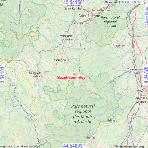
Mazet-Saint-Voy GPS coordinates[2]
45° 2' 49.056" North, 4° 14' 38.904" East
| Map corner | latitude | longitude |
|---|---|---|
| Upper-left | 45.54158°, | 3.54101° |
| Center: | 45.04696°, | 4.24414° |
| Lower-right: | 44.54803°, | 4.94726° |
| Map W x H: | 110.5×110.5 km | = 68.7×68.7mi |
| max Lat: | 51.07786° ⇑79.1% North |
| Mazet-Saint-Voy: | 45.04696° |
| min Lat: | ⇓20.9% South 41.3874° |
| min Long | Mazet-Saint-Voy | max Long |
| -5.08615° | 4.24414° | 9.52242° |
| W 70.1%⇐ | ⇒29.9% E |
Elevation
Elevation of Mazet-Saint-Voy is 1065 m = 3494 ft, and this is 871.3 m = 2859 ft above average elevation for this country.
| Max E: |
2333 m = 7654 ft | 0.7% |
| Mazet-Saint-Voy | 1065 m 3494 ft | |
| Avg. | 193.7 m = 635 ft | |
Min E: |
-1 m = -3 ft | 99.3% |
See also: France elevation on elevation.city.
Geographical zone
Mazet-Saint-Voy is located in North temperate zone (between Tropic of Cancer and the Arctic Circle). Distance of this North polar circle is 2392.4 km =1486.6 mi to North.| Distance of | km | miles | from Mazet-Saint-Voy |
|---|---|---|---|
| North Pole | 4998.3 | 3105.8 | to North |
| Arctic Circle | 2392.4 | 1486.6 | to North |
| Tropic Cancer | 2402.8 | 1493 | to South |
| Equator | 5008.8 | 3112.3 | to South |


Nearby cities:
15 places around Mazet-Saint-Voy: (largest is in red/bold)
• Araules
7.3 km =4.5 mi,  310°
310°
• Lapte
15.6 km =9.7 mi,  352°
352°
• Le Chambon-sur-Lignon
4.8 km =3 mi,  71°
71°
• Montfaucon-en-Velay
16.4 km =10.2 mi,  19°
19°
• Montregard
14.8 km =9.2 mi,  32°
32°
• Raucoules
16.1 km =10 mi,  14°
14°
• Saint-Agrève
12.6 km =7.8 mi,  108°
108°
• Saint-Front
11.2 km =7 mi,  225°
225°
• Saint-Hostien
15.8 km =9.8 mi,  280°
280°
• Saint-Jeures
6.3 km =3.9 mi,  330°
330°
• Saint-Julien-Chapteuil
14.4 km =8.9 mi,  264°
264°
• Saint-Martin-de-Valamas
15.6 km =9.7 mi,  141°
141°
• Saint-Pierre-Eynac
16.5 km =10.3 mi,  269°
269°
• Tence
8.3 km =5.2 mi, 26°
• Yssingeaux
14.2 km =8.8 mi,  318°
318°
Sources, notices
• [Note1] Compared only with cities in France existing in our database
• [Src1] Map data: © OpenStreetMap contributors (CC-BY-SA)
• [Src2] Other city data from geonames.org with taken over terms of usage.
• [Src3] Geographical zone / Annual Mean Temperature by Robert A. Rohde @ Wikipedia
