Mariac geodata
Mariac (Auvergne-Rhône-Alpes) is a populated place; located in France in Europe/Paris (GMT+2) time zone. With population of 782 people, there are 10798 cities with bigger population in this country. Compared to other cities in France, 80.6% of cities are located further ↑North; 71.2% of cities are located further ←West and 95.2% of cities have lower elevation than Mariac. Note1
Administrative division(s):
- Level 1: Auvergne-Rhône-Alpes
- Level 2: Département de l'Ardèche
- Level 3: Arrondissement de Tournon-sur-Rhône
- Level 4: Mariac


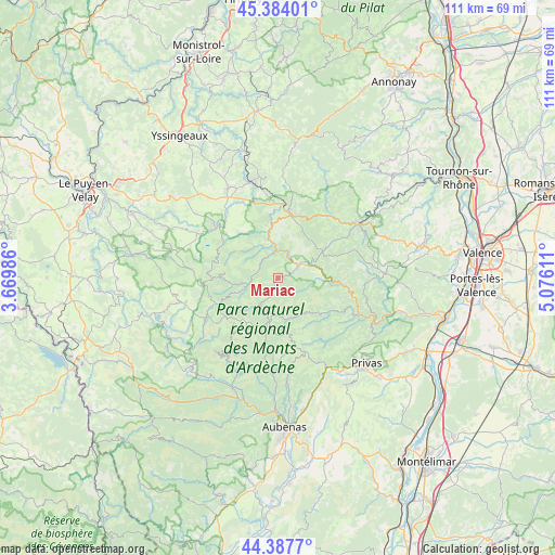
Mariac GPS coordinates[2]
44° 53' 16.836" North, 4° 22' 22.728" East
| Map corner | latitude | longitude |
|---|---|---|
| Upper-left | 45.38401°, | 3.66986° |
| Center: | 44.88801°, | 4.37298° |
| Lower-right: | 44.3877°, | 5.07611° |
| Map W x H: | 110.8×110.8 km | = 68.8×68.8mi |
| max Lat: | 51.07786° ⇑80.6% North |
| Mariac: | 44.88801° |
| min Lat: | ⇓19.4% South 41.3874° |
| min Long | Mariac | max Long |
| -5.08615° | 4.37298° | 9.52242° |
| W 71.2%⇐ | ⇒28.8% E |
Elevation
Elevation of Mariac is 600 m = 1969 ft, and this is 406.3 m = 1333 ft above average elevation for this country.
| Max E: |
2333 m = 7654 ft | 4.8% |
| Mariac | 600 m 1969 ft | |
| Avg. | 193.7 m = 635 ft | |
Min E: |
-1 m = -3 ft | 95.2% |
See also: France elevation on elevation.city.
Geographical zone
Mariac is located in North temperate zone (between Tropic of Cancer and the Arctic Circle). Distance of this Northern Tropic circle is 2385.2 km =1482.1 mi to South.| Distance of | km | miles | from Mariac |
|---|---|---|---|
| North Pole | 5016 | 3116.8 | to North |
| Arctic Circle | 2410.1 | 1497.6 | to North |
| Tropic Cancer | 2385.2 | 1482.1 | to South |
| Equator | 4991.1 | 3101.3 | to South |


Nearby cities:
15 places around Mariac: (largest is in red/bold)
• Antraigues-sur-Volane
18.9 km =11.7 mi,  183°
183°
• Burzet
19.3 km =12 mi,  211°
211°
• Désaignes
16.4 km =10.2 mi,  43°
43°
• Lamastre
19.6 km =12.2 mi,  56°
56°
• Le Chambon
7.5 km =4.7 mi,  251°
251°
• Le Chambon-sur-Lignon
20 km =12.4 mi,  343°
343°
• Le Cheylard
4.5 km =2.8 mi, 63°
• Les Ollières-sur-Eyrieux
21.2 km =13.2 mi,  116°
116°
• Mazet-Saint-Voy
20.4 km =12.7 mi,  330°
330°
• Saint-Agrève
13.7 km =8.5 mi,  7°
7°
• Saint-Front
20.6 km =12.8 mi,  298°
298°
• Saint-Martin-de-Valamas
5.5 km =3.4 mi,  356°
356°
• Saint-Pierreville
12.1 km =7.5 mi,  131°
131°
• Saint-Sauveur-de-Montagut
17.9 km =11.1 mi,  114°
114°
• Vernoux-en-Vivarais
21.5 km =13.4 mi,  87°
87°
Sources, notices
• [Note1] Compared only with cities in France existing in our database
• [Src1] Map data: © OpenStreetMap contributors (CC-BY-SA)
• [Src2] Other city data from geonames.org with taken over terms of usage.
• [Src3] Geographical zone / Annual Mean Temperature by Robert A. Rohde @ Wikipedia
