Saillagouse geodata
Saillagouse (Occitanie) is a populated place; located in France in Europe/Paris (GMT+2) time zone. With population of 906 people, there are 9605 cities with bigger population in this country. Compared to other cities in France, 99.6% of cities are located further ↑North; 56.6% of cities are located further →East and 99.8% of cities have lower elevation than Saillagouse. Note1
Administrative division(s):
- Level 1: Occitanie
- Level 2: Département des Pyrénées-Orientales
- Level 3: Arrondissement de Prades
- Level 4: Saillagouse


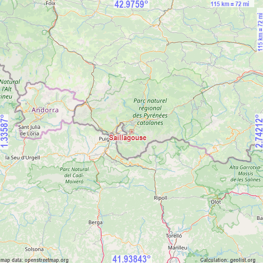
Saillagouse GPS coordinates[2]
42° 27' 33.516" North, 2° 2' 20.364" East
| Map corner | latitude | longitude |
|---|---|---|
| Upper-left | 42.9759°, | 1.33587° |
| Center: | 42.45931°, | 2.03899° |
| Lower-right: | 41.93843°, | 2.74212° |
| Map W x H: | 115.4×115.4 km | = 71.7×71.7mi |
| max Lat: | 51.07786° ⇑99.6% North |
| Saillagouse: | 42.45931° |
| min Lat: | ⇓0.4% South 41.3874° |
| min Long | Saillagouse | max Long |
| -5.08615° | 2.03899° | 9.52242° |
| W 43.4%⇐ | ⇒56.6% E |
Elevation
Elevation of Saillagouse is 1311 m = 4301 ft, and this is 1117.3 m = 3666 ft above average elevation for this country.
| Max E: |
2333 m = 7654 ft | 0.2% |
| Saillagouse | 1311 m 4301 ft | |
| Avg. | 193.7 m = 635 ft | |
Min E: |
-1 m = -3 ft | 99.8% |
See also: France elevation on elevation.city.
Geographical zone
Saillagouse is located in North temperate zone (between Tropic of Cancer and the Arctic Circle). Distance of this Northern Tropic circle is 2115.1 km =1314.3 mi to South.| Distance of | km | miles | from Saillagouse |
|---|---|---|---|
| North Pole | 5286 | 3284.6 | to North |
| Arctic Circle | 2680.1 | 1665.3 | to North |
| Tropic Cancer | 2115.1 | 1314.3 | to South |
| Equator | 4721 | 2933.5 | to South |


Nearby cities:
15 places around Saillagouse: (largest is in red/bold)
• Angostrina
7 km =4.3 mi,  291°
291°
• Ax-les-Thermes
33.3 km =20.7 mi,  330°
330°
• Bolquère
5.8 km =3.6 mi,  33°
33°
• Enveig
10.3 km =6.4 mi,  270°
270°
• Er
2 km =1.2 mi,  193°
193°
• Font-Romeu-Odeillo-Via
5.1 km =3.2 mi,  1°
1°
• La Cabanasse
7.7 km =4.8 mi,  52°
52°
• Les Angles
13.6 km =8.5 mi,  12°
12°
• Osséja
6.9 km =4.3 mi,  222°
222°
• Palau-de-Cerdagne
7.7 km =4.8 mi,  230°
230°
• Prades
36 km =22.4 mi,  60°
60°
• Prats de Molló
36.7 km =22.8 mi,  99°
99°
• Ria-Sirach
34.4 km =21.4 mi, 59°
• Vernet-les-Bains
30.2 km =18.8 mi,  70°
70°
• la Guingueta d'Ix
8.3 km =5.2 mi,  250°
250°
Sources, notices
• [Note1] Compared only with cities in France existing in our database
• [Src1] Map data: © OpenStreetMap contributors (CC-BY-SA)
• [Src2] Other city data from geonames.org with taken over terms of usage.
• [Src3] Geographical zone / Annual Mean Temperature by Robert A. Rohde @ Wikipedia
