Prades geodata
Prades (Occitanie) is a seat of a third-order administrative division; located in France in Europe/Paris (GMT+2) time zone. With population of 6,836 people, there are 1445 cities with bigger population in this country. Compared to other cities in France, 99.2% of cities are located further ↑North; 50.7% of cities are located further →East and 84.8% of cities have lower elevation than Prades. Note1
Administrative division(s):
- Level 1: Occitanie
- Level 2: Département des Pyrénées-Orientales
- Level 3: Arrondissement de Prades
- Level 4: Prades


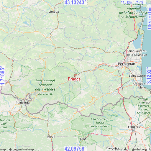
Prades GPS coordinates[2]
42° 37' 1.74" North, 2° 25' 19.488" East
| Map corner | latitude | longitude |
|---|---|---|
| Upper-left | 43.13243°, | 1.71895° |
| Center: | 42.61715°, | 2.42208° |
| Lower-right: | 42.09758°, | 3.1252° |
| Map W x H: | 115.1×115.1 km | = 71.5×71.5mi |
| max Lat: | 51.07786° ⇑99.2% North |
| Prades: | 42.61715° |
| min Lat: | ⇓0.8% South 41.3874° |
| min Long | Prades | max Long |
| -5.08615° | 2.42208° | 9.52242° |
| W 49.3%⇐ | ⇒50.7% E |
Elevation
Elevation of Prades is 343 m = 1125 ft, and this is 149.3 m = 490 ft above average elevation for this country.
| Max E: |
2333 m = 7654 ft | 15.2% |
| Prades | 343 m 1125 ft | |
| Avg. | 193.7 m = 635 ft | |
Min E: |
-1 m = -3 ft | 84.8% |
See also: France elevation on elevation.city.
Geographical zone
Prades is located in North temperate zone (between Tropic of Cancer and the Arctic Circle). Distance of this Northern Tropic circle is 2132.7 km =1325.2 mi to South.| Distance of | km | miles | from Prades |
|---|---|---|---|
| North Pole | 5268.5 | 3273.7 | to North |
| Arctic Circle | 2662.6 | 1654.5 | to North |
| Tropic Cancer | 2132.7 | 1325.2 | to South |
| Equator | 4738.6 | 2944.4 | to South |


Nearby cities:
15 places around Prades: (largest is in red/bold)
• Bouleternère
13.8 km =8.6 mi,  74°
74°
• Catllar
1.8 km =1.1 mi,  359°
359°
• Caudiès-de-Fenouillèdes
22 km =13.7 mi,  349°
349°
• Corbère
19.9 km =12.4 mi,  78°
78°
• Corbère-les-Cabanes
21.1 km =13.1 mi, 77°
• Ille-sur-Têt
17.4 km =10.8 mi, 69°
• Los Masos
2.9 km =1.8 mi,  51°
51°
• Marquixanes
5.7 km =3.5 mi,  62°
62°
• Millas
23.8 km =14.8 mi, 69°
• Néfiach
21.8 km =13.5 mi, 67°
• Ria-Sirach
1.8 km =1.1 mi,  268°
268°
• Rodès
12.3 km =7.6 mi, 68°
• Saint-Paul-de-Fenouillet
22.4 km =13.9 mi,  17°
17°
• Vernet-les-Bains
8.2 km =5.1 mi,  200°
200°
• Vinça
9.2 km =5.7 mi, 70°
Sources, notices
• [Note1] Compared only with cities in France existing in our database
• [Src1] Map data: © OpenStreetMap contributors (CC-BY-SA)
• [Src2] Other city data from geonames.org with taken over terms of usage.
• [Src3] Geographical zone / Annual Mean Temperature by Robert A. Rohde @ Wikipedia
