Rubrouck geodata
Rubrouck (Hauts-de-France) is a populated place; located in France in Europe/Paris (GMT+2) time zone. With population of 793 people, there are 10688 cities with bigger population in this country. Compared to other cities in France, 99.5% of cities are located further ↓South; 51.7% of cities are located further →East and 87.4% of cities have higher elevation than Rubrouck. Note1
Administrative division(s):
- Level 1: Hauts-de-France
- Level 2: Nord
- Level 3: Arrondissement de Dunkerque
- Level 4: Rubrouck


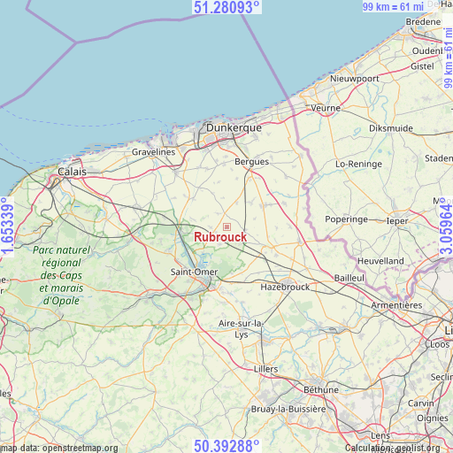
Rubrouck GPS coordinates[2]
50° 50' 20.472" North, 2° 21' 23.472" East
| Map corner | latitude | longitude |
|---|---|---|
| Upper-left | 51.28093°, | 1.65339° |
| Center: | 50.83902°, | 2.35652° |
| Lower-right: | 50.39288°, | 3.05964° |
| Map W x H: | 98.7×98.7 km | = 61.3×61.3mi |
| max Lat: | 51.07786° ⇑0.5% North |
| Rubrouck: | 50.83902° |
| min Lat: | ⇓99.5% South 41.3874° |
| min Long | Rubrouck | max Long |
| -5.08615° | 2.35652° | 9.52242° |
| W 48.3%⇐ | ⇒51.7% E |
Elevation
Elevation of Rubrouck is 36 m = 118 ft, and this is 157.7 m = 517 ft below average elevation for this country.
| Max E: |
2333 m = 7654 ft | 87.4% |
| Avg. | 193.7 m = 635 ft | |
| Rubrouck | 36 m = 118 ft | |
Min E: |
-1 m = -3 ft | 12.6% |
See also: France elevation on elevation.city.
Geographical zone
Rubrouck is located in North temperate zone (between Tropic of Cancer and the Arctic Circle). Distance of this North polar circle is 1748.4 km =1086.4 mi to North.| Distance of | km | miles | from Rubrouck |
|---|---|---|---|
| North Pole | 4354.3 | 2705.6 | to North |
| Arctic Circle | 1748.4 | 1086.4 | to North |
| Tropic Cancer | 3046.9 | 1893.3 | to South |
| Equator | 5652.8 | 3512.5 | to South |


Nearby cities:
15 places around Rubrouck: (largest is in red/bold)
• Arnèke
3.8 km =2.4 mi,  101°
101°
• Bavinchove
9.2 km =5.7 mi,  129°
129°
• Bollezeele
3.2 km =2 mi,  348°
348°
• Cassel
10 km =6.2 mi,  115°
115°
• Clairmarais
8.2 km =5.1 mi,  208°
208°
• Esquelbecq
7.5 km =4.7 mi,  44°
44°
• Lederzeele
4.3 km =2.7 mi,  241°
241°
• Ledringhem
6.3 km =3.9 mi,  72°
72°
• Merckeghem
4.9 km =3 mi,  300°
300°
• Millam
7.7 km =4.8 mi,  282°
282°
• Nieurlet
7.7 km =4.8 mi,  222°
222°
• Noordpeene
4.7 km =2.9 mi,  139°
139°
• Volckerinckhove
3.6 km =2.2 mi,  269°
269°
• Wormhout
9.2 km =5.7 mi,  59°
59°
• Zegerscappel
5.8 km =3.6 mi,  31°
31°
Sources, notices
• [Note1] Compared only with cities in France existing in our database
• [Src1] Map data: © OpenStreetMap contributors (CC-BY-SA)
• [Src2] Other city data from geonames.org with taken over terms of usage.
• [Src3] Geographical zone / Annual Mean Temperature by Robert A. Rohde @ Wikipedia
