Ledringhem geodata
Ledringhem (Hauts-de-France) is a populated place; located in France in Europe/Paris (GMT+2) time zone. With population of 526 people, there are 14691 cities with bigger population in this country. Compared to other cities in France, 99.5% of cities are located further ↓South; 50.3% of cities are located further →East and 94.4% of cities have higher elevation than Ledringhem. Note1
Administrative division(s):
- Level 1: Hauts-de-France
- Level 2: Nord
- Level 3: Arrondissement de Dunkerque
- Level 4: Ledringhem


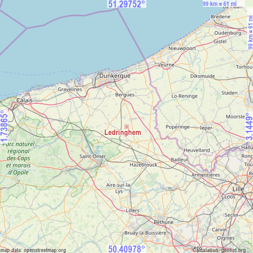
Ledringhem GPS coordinates[2]
50° 51' 20.736" North, 2° 26' 30.408" East
| Map corner | latitude | longitude |
|---|---|---|
| Upper-left | 51.29752°, | 1.73865° |
| Center: | 50.85576°, | 2.44178° |
| Lower-right: | 50.40978°, | 3.1449° |
| Map W x H: | 98.7×98.7 km | = 61.3×61.3mi |
| max Lat: | 51.07786° ⇑0.5% North |
| Ledringhem: | 50.85576° |
| min Lat: | ⇓99.5% South 41.3874° |
| min Long | Ledringhem | max Long |
| -5.08615° | 2.44178° | 9.52242° |
| W 49.7%⇐ | ⇒50.3% E |
Elevation
Elevation of Ledringhem is 19 m = 62 ft, and this is 174.7 m = 573 ft below average elevation for this country.
| Max E: |
2333 m = 7654 ft | 94.4% |
| Avg. | 193.7 m = 635 ft | |
| Ledringhem | 19 m = 62 ft | |
Min E: |
-1 m = -3 ft | 5.6% |
See also: France elevation on elevation.city.
Geographical zone
Ledringhem is located in North temperate zone (between Tropic of Cancer and the Arctic Circle). Distance of this North polar circle is 1746.5 km =1085.2 mi to North.| Distance of | km | miles | from Ledringhem |
|---|---|---|---|
| North Pole | 4352.4 | 2704.5 | to North |
| Arctic Circle | 1746.5 | 1085.2 | to North |
| Tropic Cancer | 3048.7 | 1894.4 | to South |
| Equator | 5654.6 | 3513.6 | to South |


Nearby cities:
15 places around Ledringhem: (largest is in red/bold)
• Arnèke
3.5 km =2.2 mi,  220°
220°
• Bambecque
9.1 km =5.7 mi,  55°
55°
• Bavinchove
7.8 km =4.8 mi,  172°
172°
• Bollezeele
6.7 km =4.2 mi,  280°
280°
• Cassel
6.8 km =4.2 mi,  153°
153°
• Esquelbecq
3.5 km =2.2 mi,  348°
348°
• Herzeele
7.4 km =4.6 mi, 62°
• Noordpeene
6.2 km =3.9 mi,  208°
208°
• Oudezeele
5.2 km =3.2 mi,  112°
112°
• Quaëdypre
8.9 km =5.5 mi,  5°
5°
• Rubrouck
6.3 km =3.9 mi,  252°
252°
• Socx
9 km =5.6 mi, 352°
• Winnezeele
7.9 km =4.9 mi,  102°
102°
• Wormhout
3.4 km =2.1 mi,  33°
33°
• Zegerscappel
4.2 km =2.6 mi,  316°
316°
Sources, notices
• [Note1] Compared only with cities in France existing in our database
• [Src1] Map data: © OpenStreetMap contributors (CC-BY-SA)
• [Src2] Other city data from geonames.org with taken over terms of usage.
• [Src3] Geographical zone / Annual Mean Temperature by Robert A. Rohde @ Wikipedia
