Roybon geodata
Roybon (Auvergne-Rhône-Alpes) is a populated place; located in France in Europe/Paris (GMT+2) time zone. With population of 1,364 people, there are 6749 cities with bigger population in this country. Compared to other cities in France, 76.8% of cities are located further ↑North; 80.1% of cities are located further ←West and 94% of cities have lower elevation than Roybon. Note1
Administrative division(s):
- Level 1: Auvergne-Rhône-Alpes
- Level 2: Département de l'Isère
- Level 3: Arrondissement de Vienne
- Level 4: Roybon


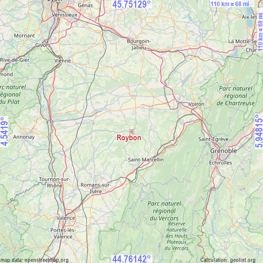
Roybon GPS coordinates[2]
45° 15' 30.636" North, 5° 14' 42.072" East
| Map corner | latitude | longitude |
|---|---|---|
| Upper-left | 45.75129°, | 4.5419° |
| Center: | 45.25851°, | 5.24502° |
| Lower-right: | 44.76142°, | 5.94815° |
| Map W x H: | 110.1×110.1 km | = 68.4×68.4mi |
| max Lat: | 51.07786° ⇑76.8% North |
| Roybon: | 45.25851° |
| min Lat: | ⇓23.2% South 41.3874° |
| min Long | Roybon | max Long |
| -5.08615° | 5.24502° | 9.52242° |
| W 80.1%⇐ | ⇒19.9% E |
Elevation
Elevation of Roybon is 542 m = 1778 ft, and this is 348.3 m = 1143 ft above average elevation for this country.
| Max E: |
2333 m = 7654 ft | 6% |
| Roybon | 542 m 1778 ft | |
| Avg. | 193.7 m = 635 ft | |
Min E: |
-1 m = -3 ft | 94% |
See also: France elevation on elevation.city.
Geographical zone
Roybon is located in North temperate zone (between Tropic of Cancer and the Arctic Circle). Distance of this North polar circle is 2368.9 km =1472 mi to North.| Distance of | km | miles | from Roybon |
|---|---|---|---|
| North Pole | 4974.8 | 3091.2 | to North |
| Arctic Circle | 2368.9 | 1472 | to North |
| Tropic Cancer | 2426.4 | 1507.7 | to South |
| Equator | 5032.3 | 3126.9 | to South |


Nearby cities:
15 places around Roybon: (largest is in red/bold)
• Brézins
11.4 km =7.1 mi,  24°
24°
• Chatte
13.2 km =8.2 mi,  167°
167°
• Chevrières
8.6 km =5.3 mi,  156°
156°
• Le Grand-Serre
11.1 km =6.9 mi,  276°
276°
• Marcilloles
10.6 km =6.6 mi,  332°
332°
• Saint-Antoine-l'Abbaye
10.5 km =6.5 mi,  192°
192°
• Saint-Pierre-de-Bressieux
7.3 km =4.5 mi,  26°
26°
• Saint-Siméon-de-Bressieux
9 km =5.6 mi,  10°
10°
• Saint-Vérand
11.7 km =7.3 mi,  144°
144°
• Saint-Étienne-de-Saint-Geoirs
12 km =7.5 mi,  41°
41°
• Sardieu
12.5 km =7.8 mi,  347°
347°
• Thodure
8.8 km =5.5 mi,  317°
317°
• Têche
13.4 km =8.3 mi,  129°
129°
• Varacieux
7.7 km =4.8 mi,  111°
111°
• Viriville
7.1 km =4.4 mi, 333°
Sources, notices
• [Note1] Compared only with cities in France existing in our database
• [Src1] Map data: © OpenStreetMap contributors (CC-BY-SA)
• [Src2] Other city data from geonames.org with taken over terms of usage.
• [Src3] Geographical zone / Annual Mean Temperature by Robert A. Rohde @ Wikipedia
