Saint-Antoine-l'Abbaye geodata
Saint-Antoine-l'Abbaye (Auvergne-Rhône-Alpes) is a populated place; located in France in Europe/Paris (GMT+2) time zone. With population of 1,008 people, there are 8781 cities with bigger population in this country. Compared to other cities in France, 77.8% of cities are located further ↑North; 79.9% of cities are located further ←West and 86% of cities have lower elevation than Saint-Antoine-l'Abbaye. Note1
Administrative division(s):
- Level 1: Auvergne-Rhône-Alpes
- Level 2: Département de l'Isère
- Level 3: Arrondissement de Grenoble
- Level 4: Saint Antoine l'Abbaye
Current local time in Saint-Antoine-l'Abbaye:
07:15 PM, SaturdayDifference from your time zone: hours


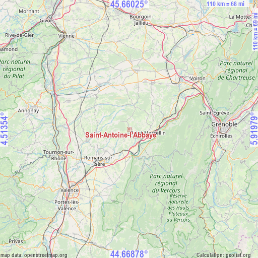
Saint-Antoine-l'Abbaye GPS coordinates[2]
45° 10' 0.012" North, 5° 13' 0.012" East
| Map corner | latitude | longitude |
|---|---|---|
| Upper-left | 45.66025°, | 4.51354° |
| Center: | 45.16667°, | 5.21667° |
| Lower-right: | 44.66878°, | 5.91979° |
| Map W x H: | 110.2×110.2 km | = 68.5×68.5mi |
| max Lat: | 51.07786° ⇑77.8% North |
| Saint-Antoine-l'Abbaye: | 45.16667° |
| min Lat: | ⇓22.2% South 41.3874° |
| min Long | Saint-Antoine-l | max Long |
| -5.08615° | 5.21667° | 9.52242° |
| W 79.9%⇐ | ⇒20.1% E |
Elevation
Elevation of Saint-Antoine-l'Abbaye is 360 m = 1181 ft, and this is 166.3 m = 546 ft above average elevation for this country.
| Max E: |
2333 m = 7654 ft | 14% |
| Saint-Antoine-l'Abbaye | 360 m 1181 ft | |
| Avg. | 193.7 m = 635 ft | |
Min E: |
-1 m = -3 ft | 86% |
See also: France elevation on elevation.city.
Geographical zone
Saint-Antoine-l'Abbaye is located in North temperate zone (between Tropic of Cancer and the Arctic Circle). Distance of this North polar circle is 2379.1 km =1478.3 mi to North.| Distance of | km | miles | from Saint-Antoine-l'Abbaye |
|---|---|---|---|
| North Pole | 4985 | 3097.5 | to North |
| Arctic Circle | 2379.1 | 1478.3 | to North |
| Tropic Cancer | 2416.1 | 1501.3 | to South |
| Equator | 5022.1 | 3120.6 | to South |


Nearby cities:
15 places around Saint-Antoine-l'Abbaye: (largest is in red/bold)
• Chatte
5.8 km =3.6 mi,  117°
117°
• Chevrières
6.1 km =3.8 mi,  67°
67°
• Châtillon-Saint-Jean
11.2 km =7 mi,  217°
217°
• Eymeux
10.4 km =6.5 mi,  196°
196°
• Geyssans
11 km =6.8 mi,  242°
242°
• La Sône
7.8 km =4.8 mi,  142°
142°
• Parnans
8.6 km =5.3 mi, 222°
• Roybon
10.5 km =6.5 mi,  12°
12°
• Saint-Bonnet-de-Chavagne
4.7 km =2.9 mi,  165°
165°
• Saint-Hilaire-du-Rosier
7.9 km =4.9 mi,  161°
161°
• Saint-Lattier
8.8 km =5.5 mi,  186°
186°
• Saint-Marcellin
8.1 km =5 mi,  103°
103°
• Saint-Romans
10.2 km =6.3 mi,  125°
125°
• Saint-Sauveur
10.8 km =6.7 mi, 97°
• Saint-Vérand
9.1 km =5.7 mi,  85°
85°
Sources, notices
• [Note1] Compared only with cities in France existing in our database
• [Src1] Map data: © OpenStreetMap contributors (CC-BY-SA)
• [Src2] Other city data from geonames.org with taken over terms of usage.
• [Src3] Geographical zone / Annual Mean Temperature by Robert A. Rohde @ Wikipedia
