Saint-Macaire-en-Mauges geodata
Saint-Macaire-en-Mauges (Pays de la Loire) is a populated place; located in France in Europe/Paris (GMT+2) time zone. With population of 6,033 people, there are 1644 cities with bigger population in this country. Compared to other cities in France, 54% of cities are located further ↑North; 88.1% of cities are located further →East and 60% of cities have higher elevation than Saint-Macaire-en-Mauges. Note1
Administrative division(s):
- Level 1: Pays de la Loire
- Level 2: Département de Maine-et-Loire
- Level 3: Arrondissement de Cholet
- Level 4: Sèvremoine
Current local time in Saint-Macaire-en-Mauges:
09:59 AM, SaturdayDifference from your time zone: hours


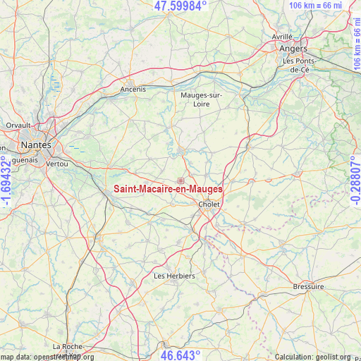
Saint-Macaire-en-Mauges GPS coordinates[2]
47° 7' 24.852" North, 0° 59' 28.32" West
| Map corner | latitude | longitude |
|---|---|---|
| Upper-left | 47.59984°, | -1.69432° |
| Center: | 47.12357°, | -0.9912° |
| Lower-right: | 46.643°, | -0.28807° |
| Map W x H: | 106.4×106.4 km | = 66.1×66.1mi |
| max Lat: | 51.07786° ⇑54% North |
| Saint-Macaire-en-Mauges: | 47.12357° |
| min Lat: | ⇓46% South 41.3874° |
| min Long | Saint-Macaire-e | max Long |
| -5.08615° | -0.9912° | 9.52242° |
| W 11.9%⇐ | ⇒88.1% E |
Elevation
Elevation of Saint-Macaire-en-Mauges is 102 m = 335 ft, and this is 91.7 m = 301 ft below average elevation for this country.
| Max E: |
2333 m = 7654 ft | 60% |
| Avg. | 193.7 m = 635 ft | |
| Saint-Macaire-en-Mauges | 102 m = 335 ft | |
Min E: |
-1 m = -3 ft | 40% |
See also: France elevation on elevation.city.
Geographical zone
Saint-Macaire-en-Mauges is located in North temperate zone (between Tropic of Cancer and the Arctic Circle). Distance of this North polar circle is 2161.5 km =1343.1 mi to North.| Distance of | km | miles | from Saint-Macaire-en-Mauges |
|---|---|---|---|
| North Pole | 4767.4 | 2962.3 | to North |
| Arctic Circle | 2161.5 | 1343.1 | to North |
| Tropic Cancer | 2633.7 | 1636.5 | to South |
| Equator | 5239.6 | 3255.7 | to South |


Nearby cities:
15 places around Saint-Macaire-en-Mauges: (largest is in red/bold)
• Andrezé
6.1 km =3.8 mi,  28°
28°
• Beaupréau
9 km =5.6 mi,  2°
2°
• Bégrolles-en-Mauges
4.3 km =2.7 mi,  64°
64°
• La Chapelle-du-Genêt
6.8 km =4.2 mi,  342°
342°
• La Jubaudière
9.2 km =5.7 mi,  54°
54°
• La Renaudière
5.1 km =3.2 mi,  265°
265°
• La Romagne
7.3 km =4.5 mi,  197°
197°
• La Séguinière
7.8 km =4.8 mi,  149°
149°
• Le May-sur-Èvre
7.6 km =4.7 mi,  78°
78°
• Montfaucon-Montigné
9.8 km =6.1 mi,  254°
254°
• Roussay
6.7 km =4.2 mi,  236°
236°
• Saint-André-de-la-Marche
2.7 km =1.7 mi,  185°
185°
• Saint-Germain-sur-Moine
9.9 km =6.2 mi, 266°
• Saint-Léger-sous-Cholet
7 km =4.3 mi,  118°
118°
• Villedieu-la-Blouère
6 km =3.7 mi,  296°
296°
Sources, notices
• [Note1] Compared only with cities in France existing in our database
• [Src1] Map data: © OpenStreetMap contributors (CC-BY-SA)
• [Src2] Other city data from geonames.org with taken over terms of usage.
• [Src3] Geographical zone / Annual Mean Temperature by Robert A. Rohde @ Wikipedia
