Roquebrune-Cap-Martin geodata
Roquebrune-Cap-Martin (Provence-Alpes-Côte d'Azur) is a populated place; located in France in Europe/Paris (GMT+2) time zone. With population of 11,834 people, there are 813 cities with bigger population in this country. Compared to other cities in France, 89.5% of cities are located further ↑North; 97.8% of cities are located further ←West and 94.4% of cities have higher elevation than Roquebrune-Cap-Martin. Note1
Administrative division(s):
- Level 1: Provence-Alpes-Côte d'Azur
- Level 2: Alpes-Maritimes
- Level 3: Arrondissement de Nice
- Level 4: Roquebrune-Cap-Martin


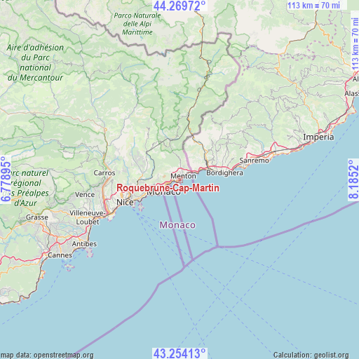
Roquebrune-Cap-Martin GPS coordinates[2]
43° 45' 50.688" North, 7° 28' 55.452" East
| Map corner | latitude | longitude |
|---|---|---|
| Upper-left | 44.26972°, | 6.77895° |
| Center: | 43.76408°, | 7.48207° |
| Lower-right: | 43.25413°, | 8.1852° |
| Map W x H: | 112.9×112.9 km | = 70.2×70.2mi |
| max Lat: | 51.07786° ⇑89.5% North |
| Roquebrune-Cap-Martin: | 43.76408° |
| min Lat: | ⇓10.5% South 41.3874° |
| min Long | Roquebrune-Cap- | max Long |
| -5.08615° | 7.48207° | 9.52242° |
| W 97.8%⇐ | ⇒2.2% E |
Elevation
Elevation of Roquebrune-Cap-Martin is 19 m = 62 ft, and this is 174.7 m = 573 ft below average elevation for this country.
| Max E: |
2333 m = 7654 ft | 94.4% |
| Avg. | 193.7 m = 635 ft | |
| Roquebrune-Cap-Martin | 19 m = 62 ft | |
Min E: |
-1 m = -3 ft | 5.6% |
See also: France elevation on elevation.city.
Geographical zone
Roquebrune-Cap-Martin is located in North temperate zone (between Tropic of Cancer and the Arctic Circle). Distance of this Northern Tropic circle is 2260.2 km =1404.4 mi to South.| Distance of | km | miles | from Roquebrune-Cap-Martin |
|---|---|---|---|
| North Pole | 5141 | 3194.5 | to North |
| Arctic Circle | 2535.1 | 1575.2 | to North |
| Tropic Cancer | 2260.2 | 1404.4 | to South |
| Equator | 4866.1 | 3023.7 | to South |


Nearby cities:
15 places around Roquebrune-Cap-Martin: (largest is in red/bold)
• Beausoleil
5.3 km =3.3 mi,  244°
244°
• Blausasc
10.5 km =6.5 mi,  296°
296°
• Cantaron
13.2 km =8.2 mi,  269°
269°
• Cap-d’Ail
7.8 km =4.8 mi,  232°
232°
• Castellar
4.6 km =2.9 mi,  14°
14°
• Drap
12.9 km =8 mi, 265°
• Gorbio
4 km =2.5 mi,  309°
309°
• La Turbie
6.9 km =4.3 mi,  252°
252°
• L’Escarène
12.9 km =8 mi, 307°
• Menton
2.3 km =1.4 mi,  52°
52°
• Peille
7.8 km =4.8 mi, 303°
• Peillon
8.1 km =5 mi,  281°
281°
• Sainte-Agnès
4.4 km =2.7 mi,  337°
337°
• Sospel
13 km =8.1 mi,  347°
347°
• Èze
10.5 km =6.5 mi, 247°
In other languages:
- In Spanish: Rocabruna
- In Italian: Roccabruna
- In Russian: Рокбрюн-Кап-Мартен
- In Chinese: 罗屈埃布兰卡马尔坦
Sources, notices
• [Note1] Compared only with cities in France existing in our database
• [Src1] Map data: © OpenStreetMap contributors (CC-BY-SA)
• [Src2] Other city data from geonames.org with taken over terms of usage.
• [Src3] Geographical zone / Annual Mean Temperature by Robert A. Rohde @ Wikipedia
