L’Escarène geodata
L’Escarène (Provence-Alpes-Côte d'Azur) is a populated place; located in France in Europe/Paris (GMT+2) time zone. With population of 2,384 people, there are 4060 cities with bigger population in this country. Compared to other cities in France, 88.7% of cities are located further ↑North; 96.9% of cities are located further ←West and 91.9% of cities have lower elevation than L’Escarène. Note1
Administrative division(s):
- Level 1: Provence-Alpes-Côte d'Azur
- Level 2: Alpes-Maritimes
- Level 3: Arrondissement de Nice
- Level 4: L'Escarène


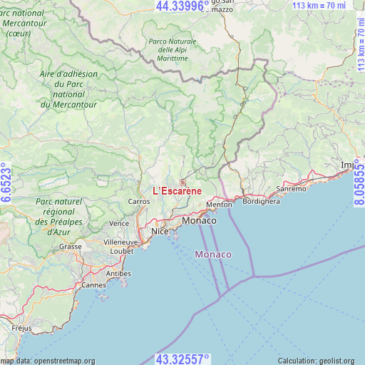
L’Escarène GPS coordinates[2]
43° 50' 5.712" North, 7° 21' 19.512" East
| Map corner | latitude | longitude |
|---|---|---|
| Upper-left | 44.33996°, | 6.6523° |
| Center: | 43.83492°, | 7.35542° |
| Lower-right: | 43.32557°, | 8.05855° |
| Map W x H: | 112.8×112.8 km | = 70.1×70.1mi |
| max Lat: | 51.07786° ⇑88.7% North |
| L’Escarène: | 43.83492° |
| min Lat: | ⇓11.3% South 41.3874° |
| min Long | L’Escarène | max Long |
| -5.08615° | 7.35542° | 9.52242° |
| W 96.9%⇐ | ⇒3.1% E |
Elevation
Elevation of L’Escarène is 474 m = 1555 ft, and this is 280.3 m = 920 ft above average elevation for this country.
| Max E: |
2333 m = 7654 ft | 8.1% |
| L’Escarène | 474 m 1555 ft | |
| Avg. | 193.7 m = 635 ft | |
Min E: |
-1 m = -3 ft | 91.9% |
See also: France elevation on elevation.city.
Geographical zone
L’Escarène is located in North temperate zone (between Tropic of Cancer and the Arctic Circle). Distance of this Northern Tropic circle is 2268.1 km =1409.3 mi to South.| Distance of | km | miles | from L’Escarène |
|---|---|---|---|
| North Pole | 5133.1 | 3189.6 | to North |
| Arctic Circle | 2527.2 | 1570.3 | to North |
| Tropic Cancer | 2268.1 | 1409.3 | to South |
| Equator | 4874 | 3028.6 | to South |


Nearby cities:
15 places around L’Escarène: (largest is in red/bold)
• Bendejun
4.9 km =3 mi,  271°
271°
• Berre-les-Alpes
2.2 km =1.4 mi,  257°
257°
• Blausasc
3.3 km =2.1 mi,  166°
166°
• Cantaron
8.7 km =5.4 mi,  200°
200°
• Coaraze
5.9 km =3.7 mi,  303°
303°
• Contes
4.1 km =2.5 mi,  233°
233°
• Drap
9.3 km =5.8 mi, 197°
• Gorbio
8.9 km =5.5 mi,  127°
127°
• Lucéram
5.4 km =3.4 mi,  3°
3°
• Peille
5.2 km =3.2 mi, 133°
• Peillon
6.6 km =4.1 mi,  160°
160°
• Saint-Blaise
9.6 km =6 mi, 261°
• Sainte-Agnès
9.3 km =5.8 mi,  114°
114°
• Sospel
8.8 km =5.5 mi,  57°
57°
• Tourrette-Levens
8.4 km =5.2 mi, 229°
Sources, notices
• [Note1] Compared only with cities in France existing in our database
• [Src1] Map data: © OpenStreetMap contributors (CC-BY-SA)
• [Src2] Other city data from geonames.org with taken over terms of usage.
• [Src3] Geographical zone / Annual Mean Temperature by Robert A. Rohde @ Wikipedia
