Drap geodata
Drap (Provence-Alpes-Côte d'Azur) is a populated place; located in France in Europe/Paris (GMT+2) time zone. With population of 4,504 people, there are 2191 cities with bigger population in this country. Compared to other cities in France, 89.7% of cities are located further ↑North; 96.7% of cities are located further ←West and 62.7% of cities have lower elevation than Drap. Note1
Administrative division(s):
- Level 1: Provence-Alpes-Côte d'Azur
- Level 2: Alpes-Maritimes
- Level 3: Arrondissement de Nice
- Level 4: Drap


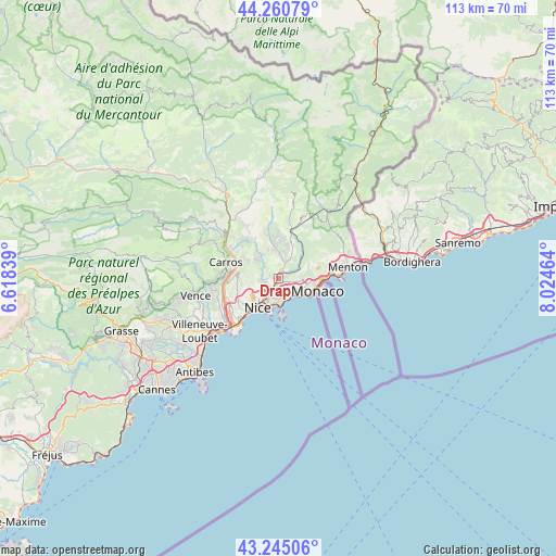
Drap GPS coordinates[2]
43° 45' 18.288" North, 7° 19' 17.472" East
| Map corner | latitude | longitude |
|---|---|---|
| Upper-left | 44.26079°, | 6.61839° |
| Center: | 43.75508°, | 7.32152° |
| Lower-right: | 43.24506°, | 8.02464° |
| Map W x H: | 112.9×112.9 km | = 70.2×70.2mi |
| max Lat: | 51.07786° ⇑89.7% North |
| Drap: | 43.75508° |
| min Lat: | ⇓10.3% South 41.3874° |
| min Long | Drap | max Long |
| -5.08615° | 7.32152° | 9.52242° |
| W 96.7%⇐ | ⇒3.3% E |
Elevation
Elevation of Drap is 183 m = 600 ft, and this is 10.7 m = 35 ft below average elevation for this country.
| Max E: |
2333 m = 7654 ft | 37.3% |
| Avg. | 193.7 m = 635 ft | |
| Drap | 183 m = 600 ft | |
Min E: |
-1 m = -3 ft | 62.7% |
See also: France elevation on elevation.city.
Geographical zone
Drap is located in North temperate zone (between Tropic of Cancer and the Arctic Circle). Distance of this Northern Tropic circle is 2259.2 km =1403.8 mi to South.| Distance of | km | miles | from Drap |
|---|---|---|---|
| North Pole | 5142 | 3195.1 | to North |
| Arctic Circle | 2536.1 | 1575.9 | to North |
| Tropic Cancer | 2259.2 | 1403.8 | to South |
| Equator | 4865.1 | 3023 | to South |


Nearby cities:
15 places around Drap: (largest is in red/bold)
• Aspremont
7 km =4.3 mi,  296°
296°
• Beaulieu-sur-Mer
5.4 km =3.4 mi,  171°
171°
• Blausasc
6.6 km =4.1 mi,  31°
31°
• Cantaron
0.8 km =0.5 mi,  337°
337°
• Contes
6.4 km =4 mi,  354°
354°
• Falicon
3.5 km =2.2 mi,  258°
258°
• La Trinité
1.7 km =1.1 mi,  200°
200°
• La Turbie
6.4 km =4 mi,  99°
99°
• Nice
7.3 km =4.5 mi,  217°
217°
• Peillon
5.6 km =3.5 mi,  61°
61°
• Saint-André-de-la-Roche
3.9 km =2.4 mi,  231°
231°
• Saint-Jean-Cap-Ferrat
7.5 km =4.7 mi, 172°
• Tourrette-Levens
5 km =3.1 mi,  313°
313°
• Villefranche-sur-Mer
5.8 km =3.6 mi,  188°
188°
• Èze
4.4 km =2.7 mi,  132°
132°
Sources, notices
• [Note1] Compared only with cities in France existing in our database
• [Src1] Map data: © OpenStreetMap contributors (CC-BY-SA)
• [Src2] Other city data from geonames.org with taken over terms of usage.
• [Src3] Geographical zone / Annual Mean Temperature by Robert A. Rohde @ Wikipedia
