Rocquigny geodata
Rocquigny (Grand Est) is a populated place; located in France in Europe/Paris (GMT+2) time zone. With population of 765 people, there are 11005 cities with bigger population in this country. Compared to other cities in France, 91.4% of cities are located further ↓South; 70.2% of cities are located further ←West and 57.1% of cities have lower elevation than Rocquigny. Note1
Administrative division(s):
- Level 1: Grand Est
- Level 2: Ardennes
- Level 3: Arrondissement de Rethel
- Level 4: Rocquigny


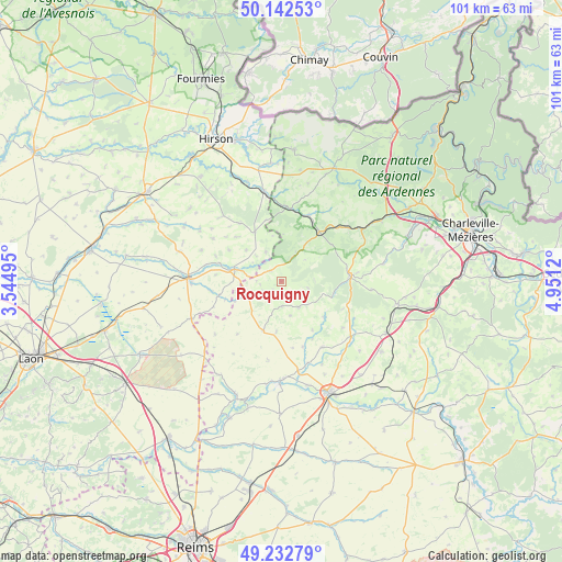
Rocquigny GPS coordinates[2]
49° 41' 23.244" North, 4° 14' 53.052" East
| Map corner | latitude | longitude |
|---|---|---|
| Upper-left | 50.14253°, | 3.54495° |
| Center: | 49.68979°, | 4.24807° |
| Lower-right: | 49.23279°, | 4.9512° |
| Map W x H: | 101.2×101.2 km | = 62.9×62.9mi |
| max Lat: | 51.07786° ⇑8.6% North |
| Rocquigny: | 49.68979° |
| min Lat: | ⇓91.4% South 41.3874° |
| min Long | Rocquigny | max Long |
| -5.08615° | 4.24807° | 9.52242° |
| W 70.2%⇐ | ⇒29.8% E |
Elevation
Elevation of Rocquigny is 158 m = 518 ft, and this is 35.7 m = 117 ft below average elevation for this country.
| Max E: |
2333 m = 7654 ft | 42.9% |
| Avg. | 193.7 m = 635 ft | |
| Rocquigny | 158 m = 518 ft | |
Min E: |
-1 m = -3 ft | 57.1% |
See also: France elevation on elevation.city.
Geographical zone
Rocquigny is located in North temperate zone (between Tropic of Cancer and the Arctic Circle). Distance of this North polar circle is 1876.2 km =1165.8 mi to North.| Distance of | km | miles | from Rocquigny |
|---|---|---|---|
| North Pole | 4482.1 | 2785 | to North |
| Arctic Circle | 1876.2 | 1165.8 | to North |
| Tropic Cancer | 2919.1 | 1813.8 | to South |
| Equator | 5525 | 3433.1 | to South |


Nearby cities:
15 places around Rocquigny: (largest is in red/bold)
• Any-Martin-Rieux
21.4 km =13.3 mi,  354°
354°
• Aubenton
16.7 km =10.4 mi, 349°
• Auvillers-les-Forges
20.9 km =13 mi,  22°
22°
• Brunehamel
10.1 km =6.3 mi,  331°
331°
• Chaourse
18 km =11.2 mi,  275°
275°
• Château-Porcien
18.1 km =11.2 mi,  180°
180°
• Dizy-le-Gros
17.5 km =10.9 mi,  247°
247°
• Launois-sur-Vence
21.4 km =13.3 mi,  100°
100°
• Liart
11 km =6.8 mi,  37°
37°
• Montcornet
16.7 km =10.4 mi,  272°
272°
• Plomion
21.1 km =13.1 mi,  309°
309°
• Rethel
21.8 km =13.5 mi,  156°
156°
• Rouvroy-sur-Audry
20.7 km =12.9 mi,  58°
58°
• Rozoy-sur-Serre
8.8 km =5.5 mi, 284°
• Saint-Germainmont
21.8 km =13.5 mi,  202°
202°
Sources, notices
• [Note1] Compared only with cities in France existing in our database
• [Src1] Map data: © OpenStreetMap contributors (CC-BY-SA)
• [Src2] Other city data from geonames.org with taken over terms of usage.
• [Src3] Geographical zone / Annual Mean Temperature by Robert A. Rohde @ Wikipedia
