Rimaucourt geodata
Rimaucourt (Grand Est) is a populated place; located in France in Europe/Paris (GMT+2) time zone. With population of 736 people, there are 11334 cities with bigger population in this country. Compared to other cities in France, 63.7% of cities are located further ↓South; 80.9% of cities are located further ←West and 76.4% of cities have lower elevation than Rimaucourt. Note1
Administrative division(s):
- Level 1: Grand Est
- Level 2: Haute-Marne
- Level 3: Arrondissement de Chaumont
- Level 4: Rimaucourt


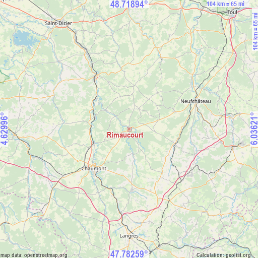
Rimaucourt GPS coordinates[2]
48° 15' 10.476" North, 5° 19' 59.088" East
| Map corner | latitude | longitude |
|---|---|---|
| Upper-left | 48.71894°, | 4.62996° |
| Center: | 48.25291°, | 5.33308° |
| Lower-right: | 47.78259°, | 6.03621° |
| Map W x H: | 104.1×104.1 km | = 64.7×64.7mi |
| max Lat: | 51.07786° ⇑36.3% North |
| Rimaucourt: | 48.25291° |
| min Lat: | ⇓63.7% South 41.3874° |
| min Long | Rimaucourt | max Long |
| -5.08615° | 5.33308° | 9.52242° |
| W 80.9%⇐ | ⇒19.1% E |
Elevation
Elevation of Rimaucourt is 259 m = 850 ft, and this is 65.3 m = 214 ft above average elevation for this country.
| Max E: |
2333 m = 7654 ft | 23.6% |
| Rimaucourt | 259 m 850 ft | |
| Avg. | 193.7 m = 635 ft | |
Min E: |
-1 m = -3 ft | 76.4% |
See also: France elevation on elevation.city.
Geographical zone
Rimaucourt is located in North temperate zone (between Tropic of Cancer and the Arctic Circle). Distance of this North polar circle is 2036 km =1265.1 mi to North.| Distance of | km | miles | from Rimaucourt |
|---|---|---|---|
| North Pole | 4641.8 | 2884.3 | to North |
| Arctic Circle | 2036 | 1265.1 | to North |
| Tropic Cancer | 2759.3 | 1714.5 | to South |
| Equator | 5365.2 | 3333.8 | to South |


Nearby cities:
15 places around Rimaucourt: (largest is in red/bold)
• Andelot-Blancheville
2.5 km =1.6 mi,  262°
262°
• Bazoilles-sur-Meuse
24.7 km =15.3 mi,  76°
76°
• Bettaincourt-sur-Rognon
8.3 km =5.2 mi,  314°
314°
• Biesles
18.8 km =11.7 mi,  188°
188°
• Bologne
15.3 km =9.5 mi,  247°
247°
• Bourmont
20.1 km =12.5 mi,  109°
109°
• Chamarandes-Choignes
23.2 km =14.4 mi,  215°
215°
• Chaumont
21.2 km =13.2 mi, 222°
• Doulaincourt-Saucourt
12.1 km =7.5 mi, 305°
• Foulain
25.4 km =15.8 mi,  200°
200°
• Froncles
14.7 km =9.1 mi,  289°
289°
• Grand
18.6 km =11.6 mi,  37°
37°
• Jonchery
22.4 km =13.9 mi,  234°
234°
• Liffol-le-Grand
19.7 km =12.2 mi,  68°
68°
• Saint-Urbain-Maconcourt
19.7 km =12.2 mi,  325°
325°
Sources, notices
• [Note1] Compared only with cities in France existing in our database
• [Src1] Map data: © OpenStreetMap contributors (CC-BY-SA)
• [Src2] Other city data from geonames.org with taken over terms of usage.
• [Src3] Geographical zone / Annual Mean Temperature by Robert A. Rohde @ Wikipedia
