Revel geodata
Revel (Occitanie) is a populated place; located in France in Europe/Paris (GMT+2) time zone. With population of 8,710 people, there are 1101 cities with bigger population in this country. Compared to other cities in France, 93.6% of cities are located further ↑North; 57.1% of cities are located further →East and 69.9% of cities have lower elevation than Revel. Note1
Administrative division(s):
- Level 1: Occitanie
- Level 2: Haute-Garonne
- Level 3: Arrondissement de Toulouse
- Level 4: Revel


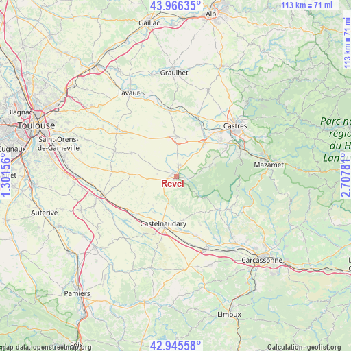
Revel GPS coordinates[2]
43° 27' 29.232" North, 2° 0' 16.884" East
| Map corner | latitude | longitude |
|---|---|---|
| Upper-left | 43.96635°, | 1.30156° |
| Center: | 43.45812°, | 2.00469° |
| Lower-right: | 42.94558°, | 2.70781° |
| Map W x H: | 113.5×113.5 km | = 70.5×70.5mi |
| max Lat: | 51.07786° ⇑93.6% North |
| Revel: | 43.45812° |
| min Lat: | ⇓6.4% South 41.3874° |
| min Long | Revel | max Long |
| -5.08615° | 2.00469° | 9.52242° |
| W 42.9%⇐ | ⇒57.1% E |
Elevation
Elevation of Revel is 219 m = 719 ft, and this is 25.3 m = 83 ft above average elevation for this country.
| Max E: |
2333 m = 7654 ft | 30.1% |
| Revel | 219 m 719 ft | |
| Avg. | 193.7 m = 635 ft | |
Min E: |
-1 m = -3 ft | 69.9% |
See also: France elevation on elevation.city.
Geographical zone
Revel is located in North temperate zone (between Tropic of Cancer and the Arctic Circle). Distance of this Northern Tropic circle is 2226.2 km =1383.3 mi to South.| Distance of | km | miles | from Revel |
|---|---|---|---|
| North Pole | 5175 | 3215.6 | to North |
| Arctic Circle | 2569.1 | 1596.4 | to North |
| Tropic Cancer | 2226.2 | 1383.3 | to South |
| Equator | 4832.1 | 3002.5 | to South |


Nearby cities:
15 places around Revel: (largest is in red/bold)
• Auriac-sur-Vendinelle
16.1 km =10 mi,  297°
297°
• Blan
7.6 km =4.7 mi,  2°
2°
• Cambounet-sur-le-Sor
16.1 km =10 mi,  34°
34°
• Castelnaudary
16.1 km =10 mi,  194°
194°
• Cuq-Toulza
14.1 km =8.8 mi,  316°
316°
• Dourgne
11.3 km =7 mi,  75°
75°
• Lempaut
9.1 km =5.7 mi, 32°
• Puylaurens
12.7 km =7.9 mi, 2°
• Saint-Félix-Lauragais
9.5 km =5.9 mi,  263°
263°
• Saint-Germain-des-Prés
12.5 km =7.8 mi,  23°
23°
• Saint-Papoul
14.4 km =8.9 mi,  169°
169°
• Saissac
17.1 km =10.6 mi,  129°
129°
• Sorèze
5.1 km =3.2 mi,  97°
97°
• Soual
14.1 km =8.8 mi,  39°
39°
• Verdalle
13.8 km =8.6 mi,  64°
64°
Sources, notices
• [Note1] Compared only with cities in France existing in our database
• [Src1] Map data: © OpenStreetMap contributors (CC-BY-SA)
• [Src2] Other city data from geonames.org with taken over terms of usage.
• [Src3] Geographical zone / Annual Mean Temperature by Robert A. Rohde @ Wikipedia
