Castelnaudary geodata
Castelnaudary (Occitanie) is a populated place; located in France in Europe/Paris (GMT+2) time zone. With population of 12,432 people, there are 765 cities with bigger population in this country. Compared to other cities in France, 95.3% of cities are located further ↑North; 57.7% of cities are located further →East and 63.6% of cities have lower elevation than Castelnaudary. Note1
Administrative division(s):
- Level 1: Occitanie
- Level 2: Département de l'Aude
- Level 3: Arrondissement de Carcassonne
- Level 4: Castelnaudary


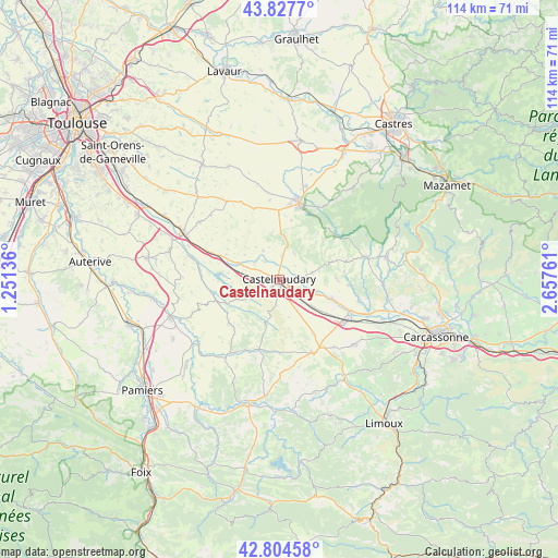
Castelnaudary GPS coordinates[2]
43° 19' 5.844" North, 1° 57' 16.164" East
| Map corner | latitude | longitude |
|---|---|---|
| Upper-left | 43.8277°, | 1.25136° |
| Center: | 43.31829°, | 1.95449° |
| Lower-right: | 42.80458°, | 2.65761° |
| Map W x H: | 113.8×113.8 km | = 70.7×70.7mi |
| max Lat: | 51.07786° ⇑95.3% North |
| Castelnaudary: | 43.31829° |
| min Lat: | ⇓4.7% South 41.3874° |
| min Long | Castelnaudary | max Long |
| -5.08615° | 1.95449° | 9.52242° |
| W 42.3%⇐ | ⇒57.7% E |
Elevation
Elevation of Castelnaudary is 187 m = 614 ft, and this is 6.7 m = 22 ft below average elevation for this country.
| Max E: |
2333 m = 7654 ft | 36.4% |
| Avg. | 193.7 m = 635 ft | |
| Castelnaudary | 187 m = 614 ft | |
Min E: |
-1 m = -3 ft | 63.6% |
See also: France elevation on elevation.city.
Geographical zone
Castelnaudary is located in North temperate zone (between Tropic of Cancer and the Arctic Circle). Distance of this Northern Tropic circle is 2210.6 km =1373.6 mi to South.| Distance of | km | miles | from Castelnaudary |
|---|---|---|---|
| North Pole | 5190.5 | 3225.2 | to North |
| Arctic Circle | 2584.6 | 1606 | to North |
| Tropic Cancer | 2210.6 | 1373.6 | to South |
| Equator | 4816.5 | 2992.8 | to South |


Nearby cities:
15 places around Castelnaudary: (largest is in red/bold)
• Avignonet-Lauragais
13.6 km =8.5 mi,  293°
293°
• Bram
15.3 km =9.5 mi,  122°
122°
• Fanjeaux
16 km =9.9 mi,  156°
156°
• Labastide-d’Anjou
8.9 km =5.5 mi, 290°
• Lasbordes
7.8 km =4.8 mi,  109°
109°
• Mas-Saintes-Puelles
6.2 km =3.9 mi,  264°
264°
• Pexiora
8.7 km =5.4 mi,  129°
129°
• Revel
16.1 km =10 mi,  14°
14°
• Saint-Félix-Lauragais
15.5 km =9.6 mi,  339°
339°
• Saint-Martin-Lalande
5.7 km =3.5 mi, 111°
• Saint-Papoul
6.8 km =4.2 mi,  78°
78°
• Salles-sur-l’Hers
14 km =8.7 mi, 258°
• Villasavary
13 km =8.1 mi,  147°
147°
• Villeneuve-la-Comptal
4.5 km =2.8 mi,  221°
221°
• Villepinte
11.5 km =7.1 mi, 110°
Sources, notices
• [Note1] Compared only with cities in France existing in our database
• [Src1] Map data: © OpenStreetMap contributors (CC-BY-SA)
• [Src2] Other city data from geonames.org with taken over terms of usage.
• [Src3] Geographical zone / Annual Mean Temperature by Robert A. Rohde @ Wikipedia
