Rethondes geodata
Rethondes (Hauts-de-France) is a populated place; located in France in Europe/Paris (GMT+2) time zone. With population of 706 people, there are 11718 cities with bigger population in this country. Compared to other cities in France, 88.2% of cities are located further ↓South; 56.9% of cities are located further ←West and 86.7% of cities have higher elevation than Rethondes. Note1
Administrative division(s):
- Level 1: Hauts-de-France
- Level 2: Département de l'Oise
- Level 3: Arrondissement de Compiègne
- Level 4: Rethondes


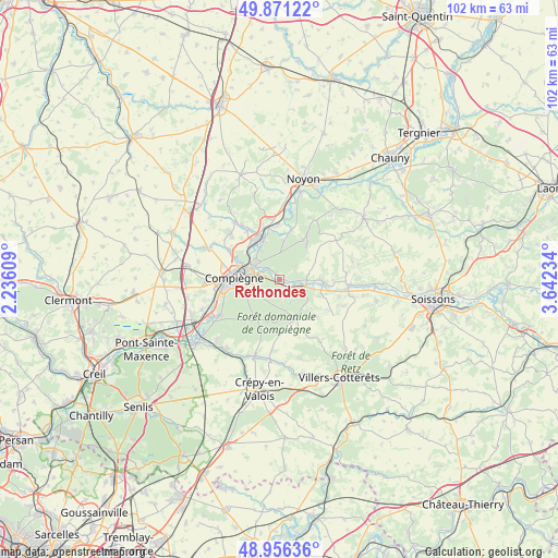
Rethondes GPS coordinates[2]
49° 24' 57.312" North, 2° 56' 21.156" East
| Map corner | latitude | longitude |
|---|---|---|
| Upper-left | 49.87122°, | 2.23609° |
| Center: | 49.41592°, | 2.93921° |
| Lower-right: | 48.95636°, | 3.64234° |
| Map W x H: | 101.7×101.7 km | = 63.2×63.2mi |
| max Lat: | 51.07786° ⇑11.8% North |
| Rethondes: | 49.41592° |
| min Lat: | ⇓88.2% South 41.3874° |
| min Long | Rethondes | max Long |
| -5.08615° | 2.93921° | 9.52242° |
| W 56.9%⇐ | ⇒43.1% E |
Elevation
Elevation of Rethondes is 38 m = 125 ft, and this is 155.7 m = 511 ft below average elevation for this country.
| Max E: |
2333 m = 7654 ft | 86.7% |
| Avg. | 193.7 m = 635 ft | |
| Rethondes | 38 m = 125 ft | |
Min E: |
-1 m = -3 ft | 13.3% |
See also: France elevation on elevation.city.
Geographical zone
Rethondes is located in North temperate zone (between Tropic of Cancer and the Arctic Circle). Distance of this North polar circle is 1906.6 km =1184.7 mi to North.| Distance of | km | miles | from Rethondes |
|---|---|---|---|
| North Pole | 4512.5 | 2803.9 | to North |
| Arctic Circle | 1906.6 | 1184.7 | to North |
| Tropic Cancer | 2888.6 | 1794.9 | to South |
| Equator | 5494.5 | 3414.1 | to South |


Nearby cities:
15 places around Rethondes: (largest is in red/bold)
• Attichy
8 km =5 mi,  93°
93°
• Berneuil-sur-Aisne
5.1 km =3.2 mi, 90°
• Choisy-au-Bac
5.1 km =3.2 mi,  298°
298°
• Clairoix
7.3 km =4.5 mi,  293°
293°
• Couloisy
6.6 km =4.1 mi,  105°
105°
• Cuise-la-Motte
5.8 km =3.6 mi,  124°
124°
• Janville
7.2 km =4.5 mi,  307°
307°
• Le Plessis-Brion
6.4 km =4 mi,  326°
326°
• Longueil-Annel
8 km =5 mi,  317°
317°
• Montmacq
7.8 km =4.8 mi,  340°
340°
• Pierrefonds
8 km =5 mi,  159°
159°
• Saint-Léger-aux-Bois
7.6 km =4.7 mi,  9°
9°
• Thourotte
7.8 km =4.8 mi, 328°
• Trosly-Breuil
2.7 km =1.7 mi,  131°
131°
• Vieux-Moulin
2.6 km =1.6 mi,  190°
190°
Sources, notices
• [Note1] Compared only with cities in France existing in our database
• [Src1] Map data: © OpenStreetMap contributors (CC-BY-SA)
• [Src2] Other city data from geonames.org with taken over terms of usage.
• [Src3] Geographical zone / Annual Mean Temperature by Robert A. Rohde @ Wikipedia
