Remoncourt geodata
Remoncourt (Grand Est) is a populated place; located in France in Europe/Paris (GMT+2) time zone. With population of 615 people, there are 13071 cities with bigger population in this country. Compared to other cities in France, 63.3% of cities are located further ↓South; 87.6% of cities are located further ←West and 82.4% of cities have lower elevation than Remoncourt. Note1
Administrative division(s):
- Level 1: Grand Est
- Level 2: Vosges
- Level 3: Arrondissement de Neufchâteau
- Level 4: Remoncourt


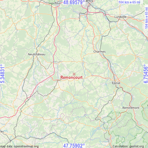
Remoncourt GPS coordinates[2]
48° 13' 46.38" North, 6° 3' 5.148" East
| Map corner | latitude | longitude |
|---|---|---|
| Upper-left | 48.69579°, | 5.34831° |
| Center: | 48.22955°, | 6.05143° |
| Lower-right: | 47.75902°, | 6.75456° |
| Map W x H: | 104.2×104.2 km | = 64.7×64.7mi |
| max Lat: | 51.07786° ⇑36.7% North |
| Remoncourt: | 48.22955° |
| min Lat: | ⇓63.3% South 41.3874° |
| min Long | Remoncourt | max Long |
| -5.08615° | 6.05143° | 9.52242° |
| W 87.6%⇐ | ⇒12.4% E |
Elevation
Elevation of Remoncourt is 315 m = 1033 ft, and this is 121.3 m = 398 ft above average elevation for this country.
| Max E: |
2333 m = 7654 ft | 17.6% |
| Remoncourt | 315 m 1033 ft | |
| Avg. | 193.7 m = 635 ft | |
Min E: |
-1 m = -3 ft | 82.4% |
See also: France elevation on elevation.city.
Geographical zone
Remoncourt is located in North temperate zone (between Tropic of Cancer and the Arctic Circle). Distance of this North polar circle is 2038.6 km =1266.7 mi to North.| Distance of | km | miles | from Remoncourt |
|---|---|---|---|
| North Pole | 4644.4 | 2885.9 | to North |
| Arctic Circle | 2038.6 | 1266.7 | to North |
| Tropic Cancer | 2756.7 | 1712.9 | to South |
| Equator | 5362.6 | 3332.2 | to South |


Nearby cities:
15 places around Remoncourt: (largest is in red/bold)
• Bulgnéville
16.3 km =10.1 mi,  261°
261°
• Chaumousey
21.9 km =13.6 mi,  106°
106°
• Châtenois
18.2 km =11.3 mi,  296°
296°
• Contrexéville
12.6 km =7.8 mi,  246°
246°
• Darney
15.9 km =9.9 mi,  180°
180°
• Dompaire
12.5 km =7.8 mi,  92°
92°
• Girancourt
20.6 km =12.8 mi, 111°
• Gironcourt-sur-Vraine
12.6 km =7.8 mi,  316°
316°
• Harol
17 km =10.6 mi,  120°
120°
• Hymont
7.9 km =4.9 mi,  57°
57°
• Martigny-les-Bains
21.8 km =13.5 mi,  230°
230°
• Mattaincourt
8.2 km =5.1 mi,  46°
46°
• Mirecourt
10 km =6.2 mi,  37°
37°
• Poussay
11.4 km =7.1 mi,  28°
28°
• Vittel
8.3 km =5.2 mi, 247°
Sources, notices
• [Note1] Compared only with cities in France existing in our database
• [Src1] Map data: © OpenStreetMap contributors (CC-BY-SA)
• [Src2] Other city data from geonames.org with taken over terms of usage.
• [Src3] Geographical zone / Annual Mean Temperature by Robert A. Rohde @ Wikipedia
