Ranville geodata
Ranville (Normandy) is a populated place; located in France in Europe/Paris (GMT+2) time zone. With population of 1,982 people, there are 4828 cities with bigger population in this country. Compared to other cities in France, 84.8% of cities are located further ↓South; 80.3% of cities are located further →East and 96.7% of cities have higher elevation than Ranville. Note1
Administrative division(s):
- Level 1: Normandy
- Level 2: Calvados
- Level 3: Arrondissement de Lisieux
- Level 4: Ranville


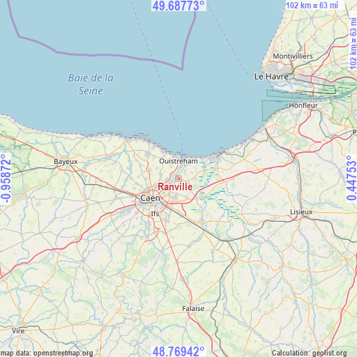
Ranville GPS coordinates[2]
49° 13' 50.556" North, 0° 15' 20.16" West
| Map corner | latitude | longitude |
|---|---|---|
| Upper-left | 49.68773°, | -0.95872° |
| Center: | 49.23071°, | -0.2556° |
| Lower-right: | 48.76942°, | 0.44753° |
| Map W x H: | 102.1×102.1 km | = 63.4×63.4mi |
| max Lat: | 51.07786° ⇑15.2% North |
| Ranville: | 49.23071° |
| min Lat: | ⇓84.8% South 41.3874° |
| min Long | Ranville | max Long |
| -5.08615° | -0.2556° | 9.52242° |
| W 19.7%⇐ | ⇒80.3% E |
Elevation
Elevation of Ranville is 12 m = 39 ft, and this is 181.7 m = 596 ft below average elevation for this country.
| Max E: |
2333 m = 7654 ft | 96.7% |
| Avg. | 193.7 m = 635 ft | |
| Ranville | 12 m = 39 ft | |
Min E: |
-1 m = -3 ft | 3.3% |
See also: France elevation on elevation.city.
Geographical zone
Ranville is located in North temperate zone (between Tropic of Cancer and the Arctic Circle). Distance of this North polar circle is 1927.2 km =1197.5 mi to North.| Distance of | km | miles | from Ranville |
|---|---|---|---|
| North Pole | 4533.1 | 2816.7 | to North |
| Arctic Circle | 1927.2 | 1197.5 | to North |
| Tropic Cancer | 2868 | 1782.1 | to South |
| Equator | 5473.9 | 3401.3 | to South |


Nearby cities:
15 places around Ranville: (largest is in red/bold)
• Amfreville
2.7 km =1.7 mi,  37°
37°
• Bavent
5 km =3.1 mi,  90°
90°
• Beuville
5.3 km =3.3 mi,  285°
285°
• Biéville-Beuville
5.4 km =3.4 mi,  284°
284°
• Blainville-sur-Orne
3.3 km =2.1 mi,  266°
266°
• Bréville-les-Monts
1.6 km =1 mi,  79°
79°
• Bénouville
2.3 km =1.4 mi,  301°
301°
• Colombelles
4.1 km =2.5 mi,  225°
225°
• Cuverville
4.6 km =2.9 mi,  188°
188°
• Démouville
5.7 km =3.5 mi, 190°
• Escoville
2.6 km =1.6 mi,  152°
152°
• Giberville
5.8 km =3.6 mi,  200°
200°
• Hérouville-Saint-Clair
4.3 km =2.7 mi,  239°
239°
• Hérouvillette
1.4 km =0.9 mi,  139°
139°
• Ouistreham
5 km =3.1 mi,  357°
357°
Sources, notices
• [Note1] Compared only with cities in France existing in our database
• [Src1] Map data: © OpenStreetMap contributors (CC-BY-SA)
• [Src2] Other city data from geonames.org with taken over terms of usage.
• [Src3] Geographical zone / Annual Mean Temperature by Robert A. Rohde @ Wikipedia
