Hérouville-Saint-Clair geodata
Hérouville-Saint-Clair (Normandy) is a populated place; located in France in Europe/Paris (GMT+2) time zone. With population of 24,258 people, there are 364 cities with bigger population in this country. Compared to other cities in France, 84.5% of cities are located further ↓South; 80.9% of cities are located further →East and 99.3% of cities have higher elevation than Hérouville-Saint-Clair. Note1
Administrative division(s):
- Level 1: Normandy
- Level 2: Calvados
- Level 3: Arrondissement de Caen
- Level 4: Hérouville-Saint-Clair
Current local time in Hérouville-Saint-Clair:
05:52 AM, WednesdayDifference from your time zone: hours


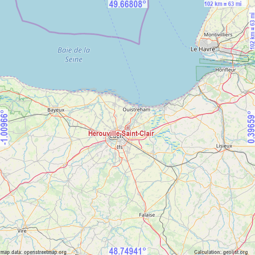
Hérouville-Saint-Clair GPS coordinates[2]
49° 12' 39.168" North, 0° 18' 23.508" West
| Map corner | latitude | longitude |
|---|---|---|
| Upper-left | 49.66808°, | -1.00966° |
| Center: | 49.21088°, | -0.30653° |
| Lower-right: | 48.74941°, | 0.39659° |
| Map W x H: | 102.1×102.1 km | = 63.4×63.4mi |
| max Lat: | 51.07786° ⇑15.5% North |
| Hérouville-Saint-Clair: | 49.21088° |
| min Lat: | ⇓84.5% South 41.3874° |
| min Long | Hérouville-Sai | max Long |
| -5.08615° | -0.30653° | 9.52242° |
| W 19.1%⇐ | ⇒80.9% E |
Elevation
Elevation of Hérouville-Saint-Clair is 5 m = 16 ft, and this is 188.7 m = 619 ft below average elevation for this country.
| Max E: |
2333 m = 7654 ft | 99.3% |
| Avg. | 193.7 m = 635 ft | |
| Hérouville-Saint-Clair | 5 m = 16 ft | |
Min E: |
-1 m = -3 ft | 0.7% |
See also: France elevation on elevation.city.
Geographical zone
Hérouville-Saint-Clair is located in North temperate zone (between Tropic of Cancer and the Arctic Circle). Distance of this North polar circle is 1929.4 km =1198.9 mi to North.| Distance of | km | miles | from Hérouville-Saint-Clair |
|---|---|---|---|
| North Pole | 4535.3 | 2818.1 | to North |
| Arctic Circle | 1929.4 | 1198.9 | to North |
| Tropic Cancer | 2865.8 | 1780.7 | to South |
| Equator | 5471.7 | 3400 | to South |


Nearby cities:
15 places around Hérouville-Saint-Clair: (largest is in red/bold)
• Beuville
3.9 km =2.4 mi,  338°
338°
• Biéville-Beuville
3.9 km =2.4 mi, 336°
• Blainville-sur-Orne
2.1 km =1.3 mi,  11°
11°
• Bréville-les-Monts
5.9 km =3.7 mi,  64°
64°
• Bénouville
3.8 km =2.4 mi,  27°
27°
• Caen
4.7 km =2.9 mi,  233°
233°
• Colombelles
1 km =0.6 mi,  130°
130°
• Cuverville
3.8 km =2.4 mi, 127°
• Démouville
4.4 km =2.7 mi,  141°
141°
• Escoville
4.9 km =3 mi,  90°
90°
• Giberville
3.7 km =2.3 mi,  153°
153°
• Hérouvillette
4.7 km =2.9 mi,  75°
75°
• Mondeville
4.2 km =2.6 mi,  196°
196°
• Ranville
4.3 km =2.7 mi, 59°
• Épron
4.8 km =3 mi,  284°
284°
In other languages:
- In Spanish: Hérouville Saint-Clair
- In Russian: Эрувиль-Сен-Клер
- In Chinese: 埃鲁维尔圣克莱
Sources, notices
• [Note1] Compared only with cities in France existing in our database
• [Src1] Map data: © OpenStreetMap contributors (CC-BY-SA)
• [Src2] Other city data from geonames.org with taken over terms of usage.
• [Src3] Geographical zone / Annual Mean Temperature by Robert A. Rohde @ Wikipedia
