Hérouvillette geodata
Hérouvillette (Normandy) is a populated place; located in France in Europe/Paris (GMT+2) time zone. With population of 1,168 people, there are 7719 cities with bigger population in this country. Compared to other cities in France, 84.7% of cities are located further ↓South; 80.2% of cities are located further →East and 95.7% of cities have higher elevation than Hérouvillette. Note1
Administrative division(s):
- Level 1: Normandy
- Level 2: Calvados
- Level 3: Arrondissement de Lisieux
- Level 4: Hérouvillette


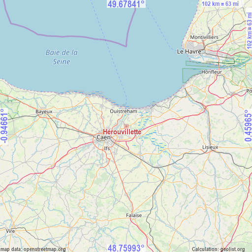
Hérouvillette GPS coordinates[2]
49° 13' 16.68" North, 0° 14' 36.528" West
| Map corner | latitude | longitude |
|---|---|---|
| Upper-left | 49.67841°, | -0.94661° |
| Center: | 49.2213°, | -0.24348° |
| Lower-right: | 48.75993°, | 0.45965° |
| Map W x H: | 102.1×102.1 km | = 63.4×63.4mi |
| max Lat: | 51.07786° ⇑15.3% North |
| Hérouvillette: | 49.2213° |
| min Lat: | ⇓84.7% South 41.3874° |
| min Long | Hérouvillette | max Long |
| -5.08615° | -0.24348° | 9.52242° |
| W 19.8%⇐ | ⇒80.2% E |
Elevation
Elevation of Hérouvillette is 15 m = 49 ft, and this is 178.7 m = 586 ft below average elevation for this country.
| Max E: |
2333 m = 7654 ft | 95.7% |
| Avg. | 193.7 m = 635 ft | |
| Hérouvillette | 15 m = 49 ft | |
Min E: |
-1 m = -3 ft | 4.3% |
See also: France elevation on elevation.city.
Geographical zone
Hérouvillette is located in North temperate zone (between Tropic of Cancer and the Arctic Circle). Distance of this North polar circle is 1928.3 km =1198.2 mi to North.| Distance of | km | miles | from Hérouvillette |
|---|---|---|---|
| North Pole | 4534.2 | 2817.4 | to North |
| Arctic Circle | 1928.3 | 1198.2 | to North |
| Tropic Cancer | 2867 | 1781.5 | to South |
| Equator | 5472.9 | 3400.7 | to South |


Nearby cities:
15 places around Hérouvillette: (largest is in red/bold)
• Amfreville
3.3 km =2.1 mi,  13°
13°
• Bavent
4.2 km =2.6 mi,  76°
76°
• Beuville
6.5 km =4 mi,  292°
292°
• Blainville-sur-Orne
4.2 km =2.6 mi,  281°
281°
• Bréville-les-Monts
1.5 km =0.9 mi,  28°
28°
• Bénouville
3.6 km =2.2 mi,  308°
308°
• Colombelles
4.2 km =2.6 mi,  244°
244°
• Cuverville
3.8 km =2.4 mi,  203°
203°
• Démouville
5 km =3.1 mi, 202°
• Escoville
1.3 km =0.8 mi,  166°
166°
• Giberville
5.3 km =3.3 mi,  213°
213°
• Hérouville-Saint-Clair
4.7 km =2.9 mi,  255°
255°
• Ouistreham
6.1 km =3.8 mi,  349°
349°
• Ranville
1.4 km =0.9 mi,  319°
319°
• Sannerville
4.8 km =3 mi,  163°
163°
Sources, notices
• [Note1] Compared only with cities in France existing in our database
• [Src1] Map data: © OpenStreetMap contributors (CC-BY-SA)
• [Src2] Other city data from geonames.org with taken over terms of usage.
• [Src3] Geographical zone / Annual Mean Temperature by Robert A. Rohde @ Wikipedia
