Rancennes geodata
Rancennes (Grand Est) is a populated place; located in France in Europe/Paris (GMT+2) time zone. With population of 835 people, there are 10242 cities with bigger population in this country. Compared to other cities in France, 94.3% of cities are located further ↓South; 75.4% of cities are located further ←West and 59.6% of cities have lower elevation than Rancennes. Note1
Administrative division(s):
- Level 1: Grand Est
- Level 2: Ardennes
- Level 3: Arrondissement de Charleville-Mézières
- Level 4: Rancennes


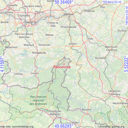
Rancennes GPS coordinates[2]
50° 6' 57.384" North, 4° 49' 8.76" East
| Map corner | latitude | longitude |
|---|---|---|
| Upper-left | 50.56469°, | 4.11597° |
| Center: | 50.11594°, | 4.8191° |
| Lower-right: | 49.66295°, | 5.52222° |
| Map W x H: | 100.3×100.3 km | = 62.3×62.3mi |
| max Lat: | 51.07786° ⇑5.7% North |
| Rancennes: | 50.11594° |
| min Lat: | ⇓94.3% South 41.3874° |
| min Long | Rancennes | max Long |
| -5.08615° | 4.8191° | 9.52242° |
| W 75.4%⇐ | ⇒24.6% E |
Elevation
Elevation of Rancennes is 168 m = 551 ft, and this is 25.7 m = 84 ft below average elevation for this country.
| Max E: |
2333 m = 7654 ft | 40.4% |
| Avg. | 193.7 m = 635 ft | |
| Rancennes | 168 m = 551 ft | |
Min E: |
-1 m = -3 ft | 59.6% |
See also: France elevation on elevation.city.
Geographical zone
Rancennes is located in North temperate zone (between Tropic of Cancer and the Arctic Circle). Distance of this North polar circle is 1828.8 km =1136.4 mi to North.| Distance of | km | miles | from Rancennes |
|---|---|---|---|
| North Pole | 4434.7 | 2755.6 | to North |
| Arctic Circle | 1828.8 | 1136.4 | to North |
| Tropic Cancer | 2966.5 | 1843.3 | to South |
| Equator | 5572.4 | 3462.5 | to South |


Nearby cities:
15 places around Rancennes: (largest is in red/bold)
• Aubrives
4.3 km =2.7 mi,  249°
249°
• Chooz
1.6 km =1 mi,  209°
209°
• Deville
27.6 km =17.1 mi,  197°
197°
• Fromelennes
3 km =1.9 mi,  74°
74°
• Fumay
16 km =9.9 mi, 209°
• Givet
2.5 km =1.6 mi,  10°
10°
• Hargnies
10.9 km =6.8 mi,  190°
190°
• Haybes
14.8 km =9.2 mi, 213°
• Laifour
24.3 km =15.1 mi, 201°
• Les Hautes-Rivières
25.6 km =15.9 mi,  176°
176°
• Monthermé
26.5 km =16.5 mi, 193°
• Revin
23.5 km =14.6 mi, 213°
• Thilay
27 km =16.8 mi, 181°
• Vireux-Molhain
7.9 km =4.9 mi,  238°
238°
• Vireux-Wallerand
7.4 km =4.6 mi, 239°
Sources, notices
• [Note1] Compared only with cities in France existing in our database
• [Src1] Map data: © OpenStreetMap contributors (CC-BY-SA)
• [Src2] Other city data from geonames.org with taken over terms of usage.
• [Src3] Geographical zone / Annual Mean Temperature by Robert A. Rohde @ Wikipedia
