Puyvert geodata
Puyvert (Provence-Alpes-Côte d'Azur) is a populated place; located in France in Europe/Paris (GMT+2) time zone. With population of 573 people, there are 13785 cities with bigger population in this country. Compared to other cities in France, 89.6% of cities are located further ↑North; 81% of cities are located further ←West and 68.5% of cities have lower elevation than Puyvert. Note1
Administrative division(s):
- Level 1: Provence-Alpes-Côte d'Azur
- Level 2: Département du Vaucluse
- Level 3: Apt
- Level 4: Puyvert


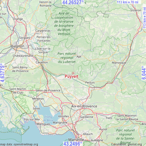
Puyvert GPS coordinates[2]
43° 45' 34.524" North, 5° 20' 27.132" East
| Map corner | latitude | longitude |
|---|---|---|
| Upper-left | 44.26527°, | 4.63775° |
| Center: | 43.75959°, | 5.34087° |
| Lower-right: | 43.2496°, | 6.044° |
| Map W x H: | 112.9×112.9 km | = 70.2×70.2mi |
| max Lat: | 51.07786° ⇑89.6% North |
| Puyvert: | 43.75959° |
| min Lat: | ⇓10.4% South 41.3874° |
| min Long | Puyvert | max Long |
| -5.08615° | 5.34087° | 9.52242° |
| W 81%⇐ | ⇒19% E |
Elevation
Elevation of Puyvert is 211 m = 692 ft, and this is 17.3 m = 57 ft above average elevation for this country.
| Max E: |
2333 m = 7654 ft | 31.5% |
| Puyvert | 211 m 692 ft | |
| Avg. | 193.7 m = 635 ft | |
Min E: |
-1 m = -3 ft | 68.5% |
See also: France elevation on elevation.city.
Geographical zone
Puyvert is located in North temperate zone (between Tropic of Cancer and the Arctic Circle). Distance of this Northern Tropic circle is 2259.7 km =1404.1 mi to South.| Distance of | km | miles | from Puyvert |
|---|---|---|---|
| North Pole | 5141.5 | 3194.8 | to North |
| Arctic Circle | 2535.6 | 1575.5 | to North |
| Tropic Cancer | 2259.7 | 1404.1 | to South |
| Equator | 4865.6 | 3023.3 | to South |


Nearby cities:
15 places around Puyvert: (largest is in red/bold)
• Ansouis
10.2 km =6.3 mi,  103°
103°
• Bonnieux
7.6 km =4.7 mi,  339°
339°
• Cadenet
3.8 km =2.4 mi,  136°
136°
• Charleval
8.9 km =5.5 mi,  239°
239°
• Cucuron
8 km =5 mi,  79°
79°
• La Roque-d’Anthéron
5.5 km =3.4 mi,  207°
207°
• Lambesc
13.4 km =8.3 mi, 208°
• Lauris
2.6 km =1.6 mi, 237°
• Le Puy-Sainte-Réparade
13 km =8.1 mi, 144°
• Lourmarin
1.8 km =1.1 mi,  74°
74°
• Mallemort
13.3 km =8.3 mi,  256°
256°
• Mérindol
11 km =6.8 mi,  267°
267°
• Puget
5.8 km =3.6 mi, 265°
• Rognes
10.7 km =6.6 mi,  177°
177°
• Villelaure
9.3 km =5.8 mi,  125°
125°
Sources, notices
• [Note1] Compared only with cities in France existing in our database
• [Src1] Map data: © OpenStreetMap contributors (CC-BY-SA)
• [Src2] Other city data from geonames.org with taken over terms of usage.
• [Src3] Geographical zone / Annual Mean Temperature by Robert A. Rohde @ Wikipedia
