Mallemort geodata
Mallemort (Provence-Alpes-Côte d'Azur) is a populated place; located in France in Europe/Paris (GMT+2) time zone. With population of 5,298 people, there are 1860 cities with bigger population in this country. Compared to other cities in France, 90% of cities are located further ↑North; 79.5% of cities are located further ←West and 50.1% of cities have lower elevation than Mallemort. Note1
Administrative division(s):
- Level 1: Provence-Alpes-Côte d'Azur
- Level 2: Département des Bouches-du-Rhône
- Level 3: Aix-en-Provence
- Level 4: Mallemort


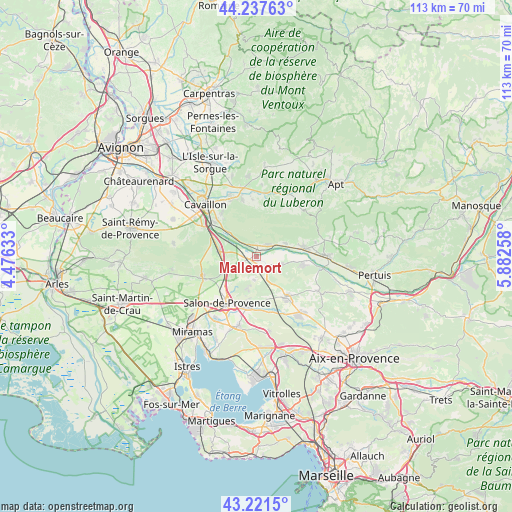
Mallemort GPS coordinates[2]
43° 43' 54.192" North, 5° 10' 46.02" East
| Map corner | latitude | longitude |
|---|---|---|
| Upper-left | 44.23763°, | 4.47633° |
| Center: | 43.73172°, | 5.17945° |
| Lower-right: | 43.2215°, | 5.88258° |
| Map W x H: | 113×113 km | = 70.2×70.2mi |
| max Lat: | 51.07786° ⇑90% North |
| Mallemort: | 43.73172° |
| min Lat: | ⇓10% South 41.3874° |
| min Long | Mallemort | max Long |
| -5.08615° | 5.17945° | 9.52242° |
| W 79.5%⇐ | ⇒20.5% E |
Elevation
Elevation of Mallemort is 132 m = 433 ft, and this is 61.7 m = 202 ft below average elevation for this country.
| Max E: |
2333 m = 7654 ft | 49.9% |
| Avg. | 193.7 m = 635 ft | |
| Mallemort | 132 m = 433 ft | |
Min E: |
-1 m = -3 ft | 50.1% |
See also: France elevation on elevation.city.
Geographical zone
Mallemort is located in North temperate zone (between Tropic of Cancer and the Arctic Circle). Distance of this Northern Tropic circle is 2256.6 km =1402.2 mi to South.| Distance of | km | miles | from Mallemort |
|---|---|---|---|
| North Pole | 5144.6 | 3196.7 | to North |
| Arctic Circle | 2538.7 | 1577.5 | to North |
| Tropic Cancer | 2256.6 | 1402.2 | to South |
| Equator | 4862.5 | 3021.4 | to South |


Nearby cities:
15 places around Mallemort: (largest is in red/bold)
• Alleins
3.4 km =2.1 mi,  204°
204°
• Aurons
7.6 km =4.7 mi,  193°
193°
• Charleval
5.5 km =3.4 mi,  105°
105°
• La Barben
11.3 km =7 mi,  181°
181°
• La Roque-d’Anthéron
10.6 km =6.6 mi,  99°
99°
• Lamanon
8.1 km =5 mi,  244°
244°
• Lambesc
10.9 km =6.8 mi,  142°
142°
• Lauris
10.9 km =6.8 mi,  80°
80°
• Ménerbes
11.4 km =7.1 mi,  10°
10°
• Mérindol
3.2 km =2 mi,  36°
36°
• Oppède le Vieux
10.9 km =6.8 mi,  352°
352°
• Puget
7.7 km =4.8 mi,  70°
70°
• Pélissanne
11.2 km =7 mi, 191°
• Sénas
8.3 km =5.2 mi,  279°
279°
• Vernègues
5.2 km =3.2 mi, 187°
Sources, notices
• [Note1] Compared only with cities in France existing in our database
• [Src1] Map data: © OpenStreetMap contributors (CC-BY-SA)
• [Src2] Other city data from geonames.org with taken over terms of usage.
• [Src3] Geographical zone / Annual Mean Temperature by Robert A. Rohde @ Wikipedia
