Pringy geodata
Pringy (Île-de-France) is a populated place; located in France in Europe/Paris (GMT+2) time zone. With population of 2,569 people, there are 3793 cities with bigger population in this country. Compared to other cities in France, 68.8% of cities are located further ↓South; 51.6% of cities are located further ←West and 71.9% of cities have higher elevation than Pringy. Note1
Administrative division(s):
- Level 1: Île-de-France
- Level 2: Seine-et-Marne
- Level 3: Arrondissement de Melun
- Level 4: Pringy


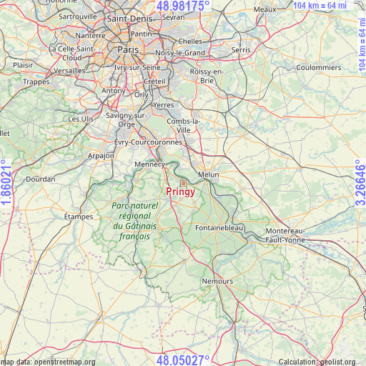
Pringy GPS coordinates[2]
48° 31' 5.34" North, 2° 33' 47.988" East
| Map corner | latitude | longitude |
|---|---|---|
| Upper-left | 48.98175°, | 1.86021° |
| Center: | 48.51815°, | 2.56333° |
| Lower-right: | 48.05027°, | 3.26646° |
| Map W x H: | 103.6×103.6 km | = 64.4×64.4mi |
| max Lat: | 51.07786° ⇑31.2% North |
| Pringy: | 48.51815° |
| min Lat: | ⇓68.8% South 41.3874° |
| min Long | Pringy | max Long |
| -5.08615° | 2.56333° | 9.52242° |
| W 51.6%⇐ | ⇒48.4% E |
Elevation
Elevation of Pringy is 74 m = 243 ft, and this is 119.7 m = 393 ft below average elevation for this country.
| Max E: |
2333 m = 7654 ft | 71.9% |
| Avg. | 193.7 m = 635 ft | |
| Pringy | 74 m = 243 ft | |
Min E: |
-1 m = -3 ft | 28.1% |
See also: France elevation on elevation.city.
Geographical zone
Pringy is located in North temperate zone (between Tropic of Cancer and the Arctic Circle). Distance of this North polar circle is 2006.5 km =1246.8 mi to North.| Distance of | km | miles | from Pringy |
|---|---|---|---|
| North Pole | 4612.3 | 2865.9 | to North |
| Arctic Circle | 2006.5 | 1246.8 | to North |
| Tropic Cancer | 2788.8 | 1732.9 | to South |
| Equator | 5394.7 | 3352.1 | to South |


Nearby cities:
15 places around Pringy: (largest is in red/bold)
• Boissise-la-Bertrand
2.2 km =1.4 mi,  59°
59°
• Boissise-le-Roi
0.9 km =0.6 mi,  32°
32°
• Cesson
5.9 km =3.7 mi, 34°
• Chailly-en-Bière
6.6 km =4.1 mi,  150°
150°
• Cély
6.9 km =4.3 mi,  199°
199°
• Dammarie-les-Lys
6.4 km =4 mi,  91°
91°
• Le Coudray-Montceaux
6.9 km =4.3 mi,  317°
317°
• Le Mée-sur-Seine
5 km =3.1 mi,  72°
72°
• Nainville-les-Roches
5.2 km =3.2 mi,  254°
254°
• Perthes
4.5 km =2.8 mi,  187°
187°
• Ponthierry
2.2 km =1.4 mi, 320°
• Saint-Fargeau-Ponthierry
5 km =3.1 mi,  329°
329°
• Saint-Sauveur-sur-École
2.6 km =1.6 mi,  207°
207°
• Savigny-le-Temple
6.4 km =4 mi,  13°
13°
• Seine-Port
4.4 km =2.7 mi,  350°
350°
Sources, notices
• [Note1] Compared only with cities in France existing in our database
• [Src1] Map data: © OpenStreetMap contributors (CC-BY-SA)
• [Src2] Other city data from geonames.org with taken over terms of usage.
• [Src3] Geographical zone / Annual Mean Temperature by Robert A. Rohde @ Wikipedia
