Savigny-le-Temple geodata
Savigny-le-Temple (Île-de-France) is a populated place; located in France in Europe/Paris (GMT+2) time zone. With population of 25,925 people, there are 332 cities with bigger population in this country. Compared to other cities in France, 70.2% of cities are located further ↓South; 51.8% of cities are located further ←West and 71.4% of cities have higher elevation than Savigny-le-Temple. Note1
Administrative division(s):
- Level 1: Île-de-France
- Level 2: Seine-et-Marne
- Level 3: Arrondissement de Melun
- Level 4: Savigny-le-Temple


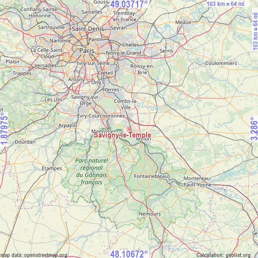
Savigny-le-Temple GPS coordinates[2]
48° 34' 26.724" North, 2° 34' 58.332" East
| Map corner | latitude | longitude |
|---|---|---|
| Upper-left | 49.03717°, | 1.87975° |
| Center: | 48.57409°, | 2.58287° |
| Lower-right: | 48.10672°, | 3.286° |
| Map W x H: | 103.5×103.5 km | = 64.3×64.3mi |
| max Lat: | 51.07786° ⇑29.8% North |
| Savigny-le-Temple: | 48.57409° |
| min Lat: | ⇓70.2% South 41.3874° |
| min Long | Savigny-le-Temp | max Long |
| -5.08615° | 2.58287° | 9.52242° |
| W 51.8%⇐ | ⇒48.2% E |
Elevation
Elevation of Savigny-le-Temple is 75 m = 246 ft, and this is 118.7 m = 389 ft below average elevation for this country.
| Max E: |
2333 m = 7654 ft | 71.4% |
| Avg. | 193.7 m = 635 ft | |
| Savigny-le-Temple | 75 m = 246 ft | |
Min E: |
-1 m = -3 ft | 28.6% |
See also: France elevation on elevation.city.
Geographical zone
Savigny-le-Temple is located in North temperate zone (between Tropic of Cancer and the Arctic Circle). Distance of this North polar circle is 2000.2 km =1242.9 mi to North.| Distance of | km | miles | from Savigny-le-Temple |
|---|---|---|---|
| North Pole | 4606.1 | 2862.1 | to North |
| Arctic Circle | 2000.2 | 1242.9 | to North |
| Tropic Cancer | 2795 | 1736.7 | to South |
| Equator | 5400.9 | 3356 | to South |


Nearby cities:
15 places around Savigny-le-Temple: (largest is in red/bold)
• Boissise-la-Bertrand
5.1 km =3.2 mi,  174°
174°
• Boissise-le-Roi
5.6 km =3.5 mi,  190°
190°
• Cesson
2.3 km =1.4 mi,  125°
125°
• Le Coudray-Montceaux
6.2 km =3.9 mi,  259°
259°
• Le Mée-sur-Seine
5.8 km =3.6 mi,  144°
144°
• Melun
6.1 km =3.8 mi,  121°
121°
• Moissy-Cramayel
5.9 km =3.7 mi,  13°
13°
• Nandy
1.8 km =1.1 mi,  304°
304°
• Ponthierry
5.3 km =3.3 mi,  212°
212°
• Pringy
6.4 km =4 mi, 193°
• Réau
5 km =3.1 mi,  36°
36°
• Saint-Fargeau-Ponthierry
4.4 km =2.7 mi,  244°
244°
• Seine-Port
2.9 km =1.8 mi,  229°
229°
• Vert-Saint-Denis
2.8 km =1.7 mi,  103°
103°
• Voisenon
6 km =3.7 mi,  92°
92°
Sources, notices
• [Note1] Compared only with cities in France existing in our database
• [Src1] Map data: © OpenStreetMap contributors (CC-BY-SA)
• [Src2] Other city data from geonames.org with taken over terms of usage.
• [Src3] Geographical zone / Annual Mean Temperature by Robert A. Rohde @ Wikipedia
