Ponthierry geodata
Ponthierry (Île-de-France) is a populated place; located in France in Europe/Paris (GMT+2) time zone. With population of 12,158 people, there are 790 cities with bigger population in this country. Compared to other cities in France, 69.2% of cities are located further ↓South; 51.3% of cities are located further ←West and 83.8% of cities have higher elevation than Ponthierry. Note1
Administrative division(s):
- Level 1: Île-de-France
- Level 2: Seine-et-Marne
- Level 3: Arrondissement de Melun
- Level 4: Saint-Fargeau-Ponthierry


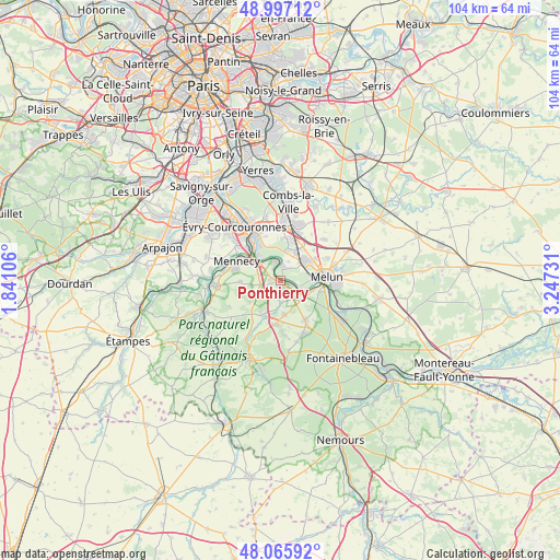
Ponthierry GPS coordinates[2]
48° 32' 1.176" North, 2° 32' 39.084" East
| Map corner | latitude | longitude |
|---|---|---|
| Upper-left | 48.99712°, | 1.84106° |
| Center: | 48.53366°, | 2.54419° |
| Lower-right: | 48.06592°, | 3.24731° |
| Map W x H: | 103.5×103.5 km | = 64.3×64.3mi |
| max Lat: | 51.07786° ⇑30.8% North |
| Ponthierry: | 48.53366° |
| min Lat: | ⇓69.2% South 41.3874° |
| min Long | Ponthierry | max Long |
| -5.08615° | 2.54419° | 9.52242° |
| W 51.3%⇐ | ⇒48.7% E |
Elevation
Elevation of Ponthierry is 45 m = 148 ft, and this is 148.7 m = 488 ft below average elevation for this country.
| Max E: |
2333 m = 7654 ft | 83.8% |
| Avg. | 193.7 m = 635 ft | |
| Ponthierry | 45 m = 148 ft | |
Min E: |
-1 m = -3 ft | 16.2% |
See also: France elevation on elevation.city.
Geographical zone
Ponthierry is located in North temperate zone (between Tropic of Cancer and the Arctic Circle). Distance of this North polar circle is 2004.7 km =1245.7 mi to North.| Distance of | km | miles | from Ponthierry |
|---|---|---|---|
| North Pole | 4610.6 | 2864.9 | to North |
| Arctic Circle | 2004.7 | 1245.7 | to North |
| Tropic Cancer | 2790.5 | 1733.9 | to South |
| Equator | 5396.4 | 3353.2 | to South |


Nearby cities:
15 places around Ponthierry: (largest is in red/bold)
• Boissise-la-Bertrand
3.4 km =2.1 mi,  99°
99°
• Boissise-le-Roi
2.1 km =1.3 mi,  117°
117°
• Cesson
5.7 km =3.5 mi,  56°
56°
• Le Coudray-Montceaux
4.7 km =2.9 mi,  315°
315°
• Le Mée-sur-Seine
6.2 km =3.9 mi,  92°
92°
• Nainville-les-Roches
4.8 km =3 mi,  229°
229°
• Nandy
5.7 km =3.5 mi,  14°
14°
• Perthes
6.2 km =3.9 mi,  172°
172°
• Pringy
2.2 km =1.4 mi,  140°
140°
• Saint-Fargeau-Ponthierry
2.9 km =1.8 mi,  335°
335°
• Saint-Sauveur-sur-École
4 km =2.5 mi,  176°
176°
• Savigny-le-Temple
5.3 km =3.3 mi,  32°
32°
• Seine-Port
2.7 km =1.7 mi, 14°
• Soisy-sur-École
7.4 km =4.6 mi,  210°
210°
• Vert-Saint-Denis
6.8 km =4.2 mi, 55°
Sources, notices
• [Note1] Compared only with cities in France existing in our database
• [Src1] Map data: © OpenStreetMap contributors (CC-BY-SA)
• [Src2] Other city data from geonames.org with taken over terms of usage.
• [Src3] Geographical zone / Annual Mean Temperature by Robert A. Rohde @ Wikipedia
