Seine-Port geodata
Seine-Port (Île-de-France) is a populated place; located in France in Europe/Paris (GMT+2) time zone. With population of 1,935 people, there are 4953 cities with bigger population in this country. Compared to other cities in France, 69.7% of cities are located further ↓South; 51.4% of cities are located further ←West and 80.2% of cities have higher elevation than Seine-Port. Note1
Administrative division(s):
- Level 1: Île-de-France
- Level 2: Seine-et-Marne
- Level 3: Arrondissement de Melun
- Level 4: Seine-Port


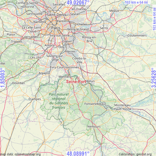
Seine-Port GPS coordinates[2]
48° 33' 26.748" North, 2° 33' 11.376" East
| Map corner | latitude | longitude |
|---|---|---|
| Upper-left | 49.02067°, | 1.85003° |
| Center: | 48.55743°, | 2.55316° |
| Lower-right: | 48.08991°, | 3.25628° |
| Map W x H: | 103.5×103.5 km | = 64.3×64.3mi |
| max Lat: | 51.07786° ⇑30.3% North |
| Seine-Port: | 48.55743° |
| min Lat: | ⇓69.7% South 41.3874° |
| min Long | Seine-Port | max Long |
| -5.08615° | 2.55316° | 9.52242° |
| W 51.4%⇐ | ⇒48.6% E |
Elevation
Elevation of Seine-Port is 54 m = 177 ft, and this is 139.7 m = 458 ft below average elevation for this country.
| Max E: |
2333 m = 7654 ft | 80.2% |
| Avg. | 193.7 m = 635 ft | |
| Seine-Port | 54 m = 177 ft | |
Min E: |
-1 m = -3 ft | 19.8% |
See also: France elevation on elevation.city.
Geographical zone
Seine-Port is located in North temperate zone (between Tropic of Cancer and the Arctic Circle). Distance of this North polar circle is 2002.1 km =1244 mi to North.| Distance of | km | miles | from Seine-Port |
|---|---|---|---|
| North Pole | 4608 | 2863.3 | to North |
| Arctic Circle | 2002.1 | 1244 | to North |
| Tropic Cancer | 2793.2 | 1735.6 | to South |
| Equator | 5399.1 | 3354.8 | to South |


Nearby cities:
15 places around Seine-Port: (largest is in red/bold)
• Boissise-la-Bertrand
4.2 km =2.6 mi,  140°
140°
• Boissise-le-Roi
3.8 km =2.4 mi,  161°
161°
• Cesson
4.1 km =2.5 mi,  82°
82°
• Corbeil-Essonnes
7.2 km =4.5 mi,  318°
318°
• Le Coudray-Montceaux
4 km =2.5 mi,  280°
280°
• Le Mée-sur-Seine
6.2 km =3.9 mi,  117°
117°
• Nainville-les-Roches
7.2 km =4.5 mi,  216°
216°
• Nandy
2.9 km =1.8 mi,  14°
14°
• Ponthierry
2.7 km =1.7 mi,  194°
194°
• Pringy
4.4 km =2.7 mi,  170°
170°
• Saint-Fargeau-Ponthierry
1.8 km =1.1 mi,  268°
268°
• Saint-Sauveur-sur-École
6.7 km =4.2 mi,  183°
183°
• Saintry-sur-Seine
6.1 km =3.8 mi, 315°
• Savigny-le-Temple
2.9 km =1.8 mi,  49°
49°
• Vert-Saint-Denis
5.1 km =3.2 mi, 76°
Sources, notices
• [Note1] Compared only with cities in France existing in our database
• [Src1] Map data: © OpenStreetMap contributors (CC-BY-SA)
• [Src2] Other city data from geonames.org with taken over terms of usage.
• [Src3] Geographical zone / Annual Mean Temperature by Robert A. Rohde @ Wikipedia
