Préaux geodata
Préaux (Normandy) is a populated place; located in France in Europe/Paris (GMT+2) time zone. With population of 1,673 people, there are 5596 cities with bigger population in this country. Compared to other cities in France, 89.1% of cities are located further ↓South; 66.6% of cities are located further →East and 58.7% of cities have lower elevation than Préaux. Note1
Administrative division(s):
- Level 1: Normandy
- Level 2: Seine-Maritime
- Level 3: Arrondissement de Rouen
- Level 4: Préaux


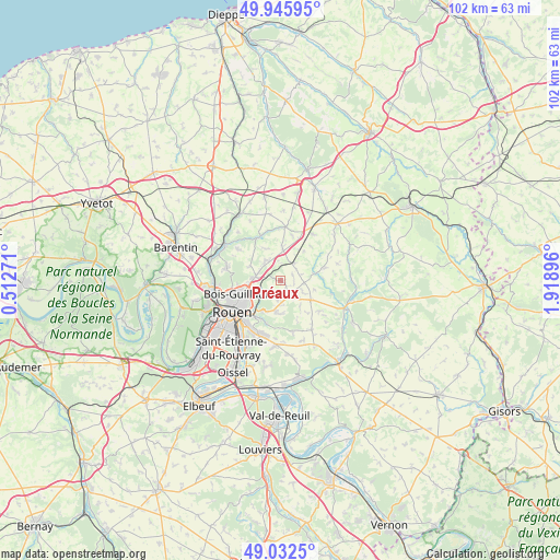
Préaux GPS coordinates[2]
49° 29' 28.896" North, 1° 12' 56.988" East
| Map corner | latitude | longitude |
|---|---|---|
| Upper-left | 49.94595°, | 0.51271° |
| Center: | 49.49136°, | 1.21583° |
| Lower-right: | 49.0325°, | 1.91896° |
| Map W x H: | 101.6×101.6 km | = 63.1×63.1mi |
| max Lat: | 51.07786° ⇑10.9% North |
| Préaux: | 49.49136° |
| min Lat: | ⇓89.1% South 41.3874° |
| min Long | Préaux | max Long |
| -5.08615° | 1.21583° | 9.52242° |
| W 33.4%⇐ | ⇒66.6% E |
Elevation
Elevation of Préaux is 164 m = 538 ft, and this is 29.7 m = 97 ft below average elevation for this country.
| Max E: |
2333 m = 7654 ft | 41.3% |
| Avg. | 193.7 m = 635 ft | |
| Préaux | 164 m = 538 ft | |
Min E: |
-1 m = -3 ft | 58.7% |
See also: France elevation on elevation.city.
Geographical zone
Préaux is located in North temperate zone (between Tropic of Cancer and the Arctic Circle). Distance of this North polar circle is 1898.3 km =1179.5 mi to North.| Distance of | km | miles | from Préaux |
|---|---|---|---|
| North Pole | 4504.1 | 2798.7 | to North |
| Arctic Circle | 1898.3 | 1179.5 | to North |
| Tropic Cancer | 2897 | 1800.1 | to South |
| Equator | 5502.9 | 3419.3 | to South |


Nearby cities:
15 places around Préaux: (largest is in red/bold)
• Bihorel
7.9 km =4.9 mi,  238°
238°
• Blainville-Crevon
6.2 km =3.9 mi,  76°
76°
• Bois-Guillaume
7.6 km =4.7 mi, 242°
• Darnétal
6.9 km =4.3 mi,  222°
222°
• Isneauville
4.5 km =2.8 mi,  279°
279°
• Martainville-Épreville
6.6 km =4.1 mi,  121°
121°
• Morgny-la-Pommeraye
3.6 km =2.2 mi,  52°
52°
• Quincampoix
4.4 km =2.7 mi,  333°
333°
• Roncherolles-sur-le-Vivier
3.6 km =2.2 mi, 220°
• Saint-André-sur-Cailly
6.2 km =3.9 mi,  2°
2°
• Saint-Georges-sur-Fontaine
6.4 km =4 mi,  336°
336°
• Saint-Jacques-sur-Darnétal
5.8 km =3.6 mi,  188°
188°
• Saint-Léger-du-Bourg-Denis
7.7 km =4.8 mi,  212°
212°
• Saint-Martin-du-Vivier
4.5 km =2.8 mi,  232°
232°
• Servaville-Salmonville
4.3 km =2.7 mi,  113°
113°
Sources, notices
• [Note1] Compared only with cities in France existing in our database
• [Src1] Map data: © OpenStreetMap contributors (CC-BY-SA)
• [Src2] Other city data from geonames.org with taken over terms of usage.
• [Src3] Geographical zone / Annual Mean Temperature by Robert A. Rohde @ Wikipedia
