Bois-Guillaume geodata
Bois-Guillaume (Normandy) is a populated place; located in France in Europe/Paris (GMT+2) time zone. With population of 13,711 people, there are 695 cities with bigger population in this country. Compared to other cities in France, 88.7% of cities are located further ↓South; 67.7% of cities are located further →East and 57.6% of cities have lower elevation than Bois-Guillaume. Note1
Administrative division(s):
- Level 1: Normandy
- Level 2: Seine-Maritime
- Level 3: Arrondissement de Rouen
- Level 4: Bois-Guillaume


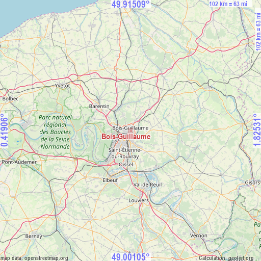
Bois-Guillaume GPS coordinates[2]
49° 27' 36.72" North, 1° 7' 19.884" East
| Map corner | latitude | longitude |
|---|---|---|
| Upper-left | 49.91509°, | 0.41906° |
| Center: | 49.4602°, | 1.12219° |
| Lower-right: | 49.00105°, | 1.82531° |
| Map W x H: | 101.6×101.6 km | = 63.1×63.1mi |
| max Lat: | 51.07786° ⇑11.3% North |
| Bois-Guillaume: | 49.4602° |
| min Lat: | ⇓88.7% South 41.3874° |
| min Long | Bois-Guillaume | max Long |
| -5.08615° | 1.12219° | 9.52242° |
| W 32.3%⇐ | ⇒67.7% E |
Elevation
Elevation of Bois-Guillaume is 160 m = 525 ft, and this is 33.7 m = 111 ft below average elevation for this country.
| Max E: |
2333 m = 7654 ft | 42.4% |
| Avg. | 193.7 m = 635 ft | |
| Bois-Guillaume | 160 m = 525 ft | |
Min E: |
-1 m = -3 ft | 57.6% |
See also: France elevation on elevation.city.
Geographical zone
Bois-Guillaume is located in North temperate zone (between Tropic of Cancer and the Arctic Circle). Distance of this North polar circle is 1901.7 km =1181.7 mi to North.| Distance of | km | miles | from Bois-Guillaume |
|---|---|---|---|
| North Pole | 4507.6 | 2800.9 | to North |
| Arctic Circle | 1901.7 | 1181.7 | to North |
| Tropic Cancer | 2893.5 | 1797.9 | to South |
| Equator | 5499.5 | 3417.2 | to South |


Nearby cities:
15 places around Bois-Guillaume: (largest is in red/bold)
• Amfreville-la-Mi-Voie
6 km =3.7 mi,  168°
168°
• Bihorel
0.6 km =0.4 mi,  179°
179°
• Darnétal
2.7 km =1.7 mi,  128°
128°
• Déville-lès-Rouen
5.2 km =3.2 mi,  281°
281°
• Isneauville
4.8 km =3 mi,  28°
28°
• Le Mesnil-Esnard
5.5 km =3.4 mi,  162°
162°
• Mont-Saint-Aignan
2.1 km =1.3 mi, 278°
• Notre-Dame-de-Bondeville
5.8 km =3.6 mi,  296°
296°
• Roncherolles-sur-le-Vivier
4.5 km =2.8 mi,  80°
80°
• Rouen
2.5 km =1.6 mi,  221°
221°
• Saint-Aubin-Épinay
5.8 km =3.6 mi,  146°
146°
• Saint-Jacques-sur-Darnétal
6.3 km =3.9 mi,  111°
111°
• Saint-Léger-du-Bourg-Denis
3.9 km =2.4 mi,  138°
138°
• Saint-Martin-du-Vivier
3.3 km =2.1 mi, 77°
• Sotteville-lès-Rouen
6.1 km =3.8 mi,  202°
202°
Sources, notices
• [Note1] Compared only with cities in France existing in our database
• [Src1] Map data: © OpenStreetMap contributors (CC-BY-SA)
• [Src2] Other city data from geonames.org with taken over terms of usage.
• [Src3] Geographical zone / Annual Mean Temperature by Robert A. Rohde @ Wikipedia
