Pont-l’Évêque geodata
Pont-l’Évêque (Normandy) is a populated place; located in France in Europe/Paris (GMT+2) time zone. With population of 4,739 people, there are 2092 cities with bigger population in this country. Compared to other cities in France, 85.8% of cities are located further ↓South; 76.4% of cities are located further →East and 96.7% of cities have higher elevation than Pont-l’Évêque. Note1
Administrative division(s):
- Level 1: Normandy
- Level 2: Calvados
- Level 3: Arrondissement de Lisieux
- Level 4: Pont-l'Évêque


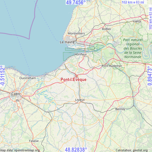
Pont-l’Évêque GPS coordinates[2]
49° 17' 20.832" North, 0° 11' 29.796" East
| Map corner | latitude | longitude |
|---|---|---|
| Upper-left | 49.7456°, | -0.51152° |
| Center: | 49.28912°, | 0.19161° |
| Lower-right: | 48.82838°, | 0.89473° |
| Map W x H: | 102×102 km | = 63.4×63.4mi |
| max Lat: | 51.07786° ⇑14.2% North |
| Pont-l’Évêque: | 49.28912° |
| min Lat: | ⇓85.8% South 41.3874° |
| min Long | Pont-l’Évêq | max Long |
| -5.08615° | 0.19161° | 9.52242° |
| W 23.6%⇐ | ⇒76.4% E |
Elevation
Elevation of Pont-l’Évêque is 12 m = 39 ft, and this is 181.7 m = 596 ft below average elevation for this country.
| Max E: |
2333 m = 7654 ft | 96.7% |
| Avg. | 193.7 m = 635 ft | |
| Pont-l’Évêque | 12 m = 39 ft | |
Min E: |
-1 m = -3 ft | 3.3% |
See also: France elevation on elevation.city.
Geographical zone
Pont-l’Évêque is located in North temperate zone (between Tropic of Cancer and the Arctic Circle). Distance of this North polar circle is 1920.7 km =1193.5 mi to North.| Distance of | km | miles | from Pont-l’Évêque |
|---|---|---|---|
| North Pole | 4526.6 | 2812.7 | to North |
| Arctic Circle | 1920.7 | 1193.5 | to North |
| Tropic Cancer | 2874.5 | 1786.1 | to South |
| Equator | 5480.4 | 3405.4 | to South |


Nearby cities:
15 places around Pont-l’Évêque: (largest is in red/bold)
• Beaumont-en-Auge
6 km =3.7 mi,  258°
258°
• Blangy-le-Château
7.8 km =4.8 mi,  130°
130°
• Bonneville-la-Louvet
10.4 km =6.5 mi,  100°
100°
• Coquainvilliers
10.2 km =6.3 mi,  172°
172°
• Deauville
11.6 km =7.2 mi,  310°
310°
• Genneville
10.8 km =6.7 mi,  34°
34°
• Gonneville-sur-Honfleur
11.3 km =7 mi,  20°
20°
• Le Breuil-en-Auge
7.1 km =4.4 mi,  160°
160°
• Saint-Arnoult
9.1 km =5.7 mi, 306°
• Saint-Gatien-des-Bois
6.8 km =4.2 mi,  354°
354°
• Saint-Hymer
4.2 km =2.6 mi,  197°
197°
• Saint-Philbert-des-Champs
11.1 km =6.9 mi,  143°
143°
• Touques
8.9 km =5.5 mi, 313°
• Tourgeville
9.5 km =5.9 mi,  292°
292°
• Équemauville
11.7 km =7.3 mi,  5°
5°
Sources, notices
• [Note1] Compared only with cities in France existing in our database
• [Src1] Map data: © OpenStreetMap contributors (CC-BY-SA)
• [Src2] Other city data from geonames.org with taken over terms of usage.
• [Src3] Geographical zone / Annual Mean Temperature by Robert A. Rohde @ Wikipedia
