Saint-Philbert-des-Champs geodata
Saint-Philbert-des-Champs (Normandy) is a populated place; located in France in Europe/Paris (GMT+2) time zone. With population of 640 people, there are 12673 cities with bigger population in this country. Compared to other cities in France, 84.4% of cities are located further ↓South; 75.5% of cities are located further →East and 55.9% of cities have lower elevation than Saint-Philbert-des-Champs. Note1
Administrative division(s):
- Level 1: Normandy
- Level 2: Calvados
- Level 3: Arrondissement de Lisieux
- Level 4: Saint-Philbert-des-Champs
Current local time in Saint-Philbert-des-Champs:
12:28 PM, MondayDifference from your time zone: hours


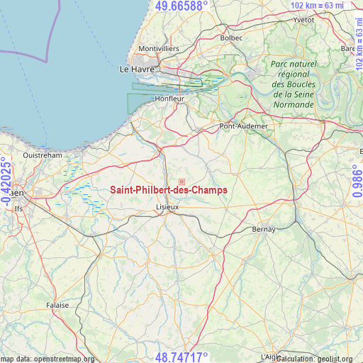
Saint-Philbert-des-Champs GPS coordinates[2]
49° 12' 31.176" North, 0° 16' 58.332" East
| Map corner | latitude | longitude |
|---|---|---|
| Upper-left | 49.66588°, | -0.42025° |
| Center: | 49.20866°, | 0.28287° |
| Lower-right: | 48.74717°, | 0.986° |
| Map W x H: | 102.2×102.1 km | = 63.5×63.4mi |
| max Lat: | 51.07786° ⇑15.6% North |
| Saint-Philbert-des-Champs: | 49.20866° |
| min Lat: | ⇓84.4% South 41.3874° |
| min Long | Saint-Philbert- | max Long |
| -5.08615° | 0.28287° | 9.52242° |
| W 24.5%⇐ | ⇒75.5% E |
Elevation
Elevation of Saint-Philbert-des-Champs is 153 m = 502 ft, and this is 40.7 m = 134 ft below average elevation for this country.
| Max E: |
2333 m = 7654 ft | 44.1% |
| Avg. | 193.7 m = 635 ft | |
| Saint-Philbert-des-Champs | 153 m = 502 ft | |
Min E: |
-1 m = -3 ft | 55.9% |
See also: France elevation on elevation.city.
Geographical zone
Saint-Philbert-des-Champs is located in North temperate zone (between Tropic of Cancer and the Arctic Circle). Distance of this North polar circle is 1929.7 km =1199.1 mi to North.| Distance of | km | miles | from Saint-Philbert-des-Champs |
|---|---|---|---|
| North Pole | 4535.6 | 2818.3 | to North |
| Arctic Circle | 1929.7 | 1199.1 | to North |
| Tropic Cancer | 2865.6 | 1780.6 | to South |
| Equator | 5471.5 | 3399.8 | to South |


Nearby cities:
15 places around Saint-Philbert-des-Champs: (largest is in red/bold)
• Beuvillers
9 km =5.6 mi,  193°
193°
• Blangy-le-Château
3.9 km =2.4 mi,  349°
349°
• Bonneville-la-Louvet
7.9 km =4.9 mi,  26°
26°
• Coquainvilliers
5.5 km =3.4 mi,  257°
257°
• Cormeilles
8.1 km =5 mi,  57°
57°
• Courtonne-la-Meurdrac
9.6 km =6 mi,  163°
163°
• Hermival-les-Vaux
4.5 km =2.8 mi,  181°
181°
• Le Breuil-en-Auge
4.8 km =3 mi,  297°
297°
• Le Pin
3.8 km =2.4 mi,  85°
85°
• Lisieux
7.9 km =4.9 mi,  209°
209°
• Manerbe
8.3 km =5.2 mi,  251°
251°
• Moyaux
5.5 km =3.4 mi,  105°
105°
• Ouilly-le-Vicomte
5.2 km =3.2 mi,  236°
236°
• Saint-Désir
9.1 km =5.7 mi, 213°
• Saint-Hymer
9.3 km =5.8 mi, 301°
Sources, notices
• [Note1] Compared only with cities in France existing in our database
• [Src1] Map data: © OpenStreetMap contributors (CC-BY-SA)
• [Src2] Other city data from geonames.org with taken over terms of usage.
• [Src3] Geographical zone / Annual Mean Temperature by Robert A. Rohde @ Wikipedia
