Le Breuil-en-Auge geodata
Le Breuil-en-Auge (Normandy) is a populated place; located in France in Europe/Paris (GMT+2) time zone. With population of 891 people, there are 9734 cities with bigger population in this country. Compared to other cities in France, 84.8% of cities are located further ↓South; 76% of cities are located further →East and 88.6% of cities have higher elevation than Le Breuil-en-Auge. Note1
Administrative division(s):
- Level 1: Normandy
- Level 2: Calvados
- Level 3: Arrondissement de Lisieux
- Level 4: Le Breuil-en-Auge


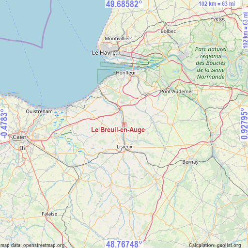
Le Breuil-en-Auge GPS coordinates[2]
49° 13' 43.608" North, 0° 13' 29.388" East
| Map corner | latitude | longitude |
|---|---|---|
| Upper-left | 49.68582°, | -0.4783° |
| Center: | 49.22878°, | 0.22483° |
| Lower-right: | 48.76748°, | 0.92795° |
| Map W x H: | 102.1×102.1 km | = 63.4×63.4mi |
| max Lat: | 51.07786° ⇑15.2% North |
| Le Breuil-en-Auge: | 49.22878° |
| min Lat: | ⇓84.8% South 41.3874° |
| min Long | Le Breuil-en-Au | max Long |
| -5.08615° | 0.22483° | 9.52242° |
| W 24%⇐ | ⇒76% E |
Elevation
Elevation of Le Breuil-en-Auge is 33 m = 108 ft, and this is 160.7 m = 527 ft below average elevation for this country.
| Max E: |
2333 m = 7654 ft | 88.6% |
| Avg. | 193.7 m = 635 ft | |
| Le Breuil-en-Auge | 33 m = 108 ft | |
Min E: |
-1 m = -3 ft | 11.4% |
See also: France elevation on elevation.city.
Geographical zone
Le Breuil-en-Auge is located in North temperate zone (between Tropic of Cancer and the Arctic Circle). Distance of this North polar circle is 1927.4 km =1197.6 mi to North.| Distance of | km | miles | from Le Breuil-en-Auge |
|---|---|---|---|
| North Pole | 4533.3 | 2816.9 | to North |
| Arctic Circle | 1927.4 | 1197.6 | to North |
| Tropic Cancer | 2867.8 | 1782 | to South |
| Equator | 5473.7 | 3401.2 | to South |


Nearby cities:
15 places around Le Breuil-en-Auge: (largest is in red/bold)
• Beaumont-en-Auge
10 km =6.2 mi,  303°
303°
• Blangy-le-Château
3.9 km =2.4 mi,  65°
65°
• Bonnebosq
11 km =6.8 mi,  255°
255°
• Bonneville-la-Louvet
9.1 km =5.7 mi,  58°
58°
• Coquainvilliers
3.6 km =2.2 mi,  197°
197°
• Hermival-les-Vaux
7.9 km =4.9 mi,  148°
148°
• Le Pin
8.2 km =5.1 mi,  103°
103°
• Lisieux
9.1 km =5.7 mi,  177°
177°
• Manerbe
6.1 km =3.8 mi,  217°
217°
• Moyaux
10.2 km =6.3 mi,  111°
111°
• Ouilly-le-Vicomte
5.1 km =3.2 mi, 181°
• Pont-l’Évêque
7.1 km =4.4 mi,  340°
340°
• Saint-Désir
9.8 km =6.1 mi, 184°
• Saint-Hymer
4.6 km =2.9 mi,  306°
306°
• Saint-Philbert-des-Champs
4.8 km =3 mi,  117°
117°
Sources, notices
• [Note1] Compared only with cities in France existing in our database
• [Src1] Map data: © OpenStreetMap contributors (CC-BY-SA)
• [Src2] Other city data from geonames.org with taken over terms of usage.
• [Src3] Geographical zone / Annual Mean Temperature by Robert A. Rohde @ Wikipedia
