Saint-Hymer geodata
Saint-Hymer (Normandy) is a populated place; located in France in Europe/Paris (GMT+2) time zone. With population of 700 people, there are 11801 cities with bigger population in this country. Compared to other cities in France, 85.2% of cities are located further ↓South; 76.5% of cities are located further →East and 75.8% of cities have higher elevation than Saint-Hymer. Note1
Administrative division(s):
- Level 1: Normandy
- Level 2: Calvados
- Level 3: Arrondissement de Lisieux
- Level 4: Saint-Hymer


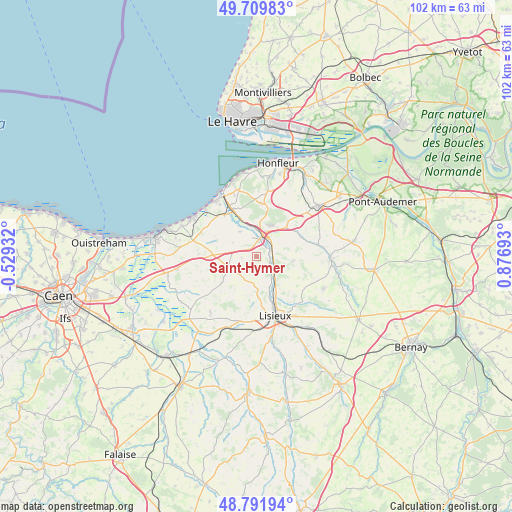
Saint-Hymer GPS coordinates[2]
49° 15' 10.872" North, 0° 10' 25.68" East
| Map corner | latitude | longitude |
|---|---|---|
| Upper-left | 49.70983°, | -0.52932° |
| Center: | 49.25302°, | 0.1738° |
| Lower-right: | 48.79194°, | 0.87693° |
| Map W x H: | 102.1×102.1 km | = 63.4×63.4mi |
| max Lat: | 51.07786° ⇑14.8% North |
| Saint-Hymer: | 49.25302° |
| min Lat: | ⇓85.2% South 41.3874° |
| min Long | Saint-Hymer | max Long |
| -5.08615° | 0.1738° | 9.52242° |
| W 23.5%⇐ | ⇒76.5% E |
Elevation
Elevation of Saint-Hymer is 65 m = 213 ft, and this is 128.7 m = 422 ft below average elevation for this country.
| Max E: |
2333 m = 7654 ft | 75.8% |
| Avg. | 193.7 m = 635 ft | |
| Saint-Hymer | 65 m = 213 ft | |
Min E: |
-1 m = -3 ft | 24.2% |
See also: France elevation on elevation.city.
Geographical zone
Saint-Hymer is located in North temperate zone (between Tropic of Cancer and the Arctic Circle). Distance of this North polar circle is 1924.8 km =1196 mi to North.| Distance of | km | miles | from Saint-Hymer |
|---|---|---|---|
| North Pole | 4530.6 | 2815.2 | to North |
| Arctic Circle | 1924.8 | 1196 | to North |
| Tropic Cancer | 2870.5 | 1783.6 | to South |
| Equator | 5476.4 | 3402.9 | to South |


Nearby cities:
15 places around Saint-Hymer: (largest is in red/bold)
• Beaumont-en-Auge
5.4 km =3.4 mi,  301°
301°
• Blangy-le-Château
7.3 km =4.5 mi,  98°
98°
• Bonnebosq
8.9 km =5.5 mi,  231°
231°
• Bonneville-la-Louvet
11.7 km =7.3 mi,  79°
79°
• Coquainvilliers
6.7 km =4.2 mi,  157°
157°
• Hermival-les-Vaux
12.2 km =7.6 mi,  140°
140°
• Le Breuil-en-Auge
4.6 km =2.9 mi,  126°
126°
• Manerbe
7.6 km =4.7 mi,  179°
179°
• Ouilly-le-Vicomte
8.6 km =5.3 mi, 155°
• Pont-l’Évêque
4.2 km =2.6 mi,  17°
17°
• Saint-Arnoult
11.2 km =7 mi,  327°
327°
• Saint-Gatien-des-Bois
10.8 km =6.7 mi,  3°
3°
• Saint-Philbert-des-Champs
9.3 km =5.8 mi,  121°
121°
• Touques
11.4 km =7.1 mi, 332°
• Tourgeville
10.7 km =6.6 mi,  315°
315°
Sources, notices
• [Note1] Compared only with cities in France existing in our database
• [Src1] Map data: © OpenStreetMap contributors (CC-BY-SA)
• [Src2] Other city data from geonames.org with taken over terms of usage.
• [Src3] Geographical zone / Annual Mean Temperature by Robert A. Rohde @ Wikipedia
