Pont-de-Roide geodata
Pont-de-Roide (Bourgogne-Franche-Comté) is a populated place; located in France in Europe/Paris (GMT+2) time zone. With population of 4,989 people, there are 1987 cities with bigger population in this country. Compared to other cities in France, 50.3% of cities are located further ↑North; 93.5% of cities are located further ←West and 85.8% of cities have lower elevation than Pont-de-Roide. Note1
Administrative division(s):
- Level 1: Bourgogne-Franche-Comté
- Level 2: Doubs
- Level 3: Arrondissement de Montbéliard
- Level 4: Pont-de-Roide-Vermondans


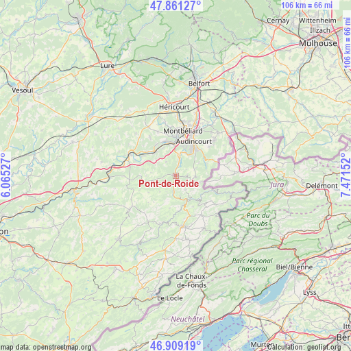
Pont-de-Roide GPS coordinates[2]
47° 23' 14.568" North, 6° 46' 6.24" East
| Map corner | latitude | longitude |
|---|---|---|
| Upper-left | 47.86127°, | 6.06527° |
| Center: | 47.38738°, | 6.7684° |
| Lower-right: | 46.90919°, | 7.47152° |
| Map W x H: | 105.9×105.9 km | = 65.8×65.8mi |
| max Lat: | 51.07786° ⇑50.3% North |
| Pont-de-Roide: | 47.38738° |
| min Lat: | ⇓49.7% South 41.3874° |
| min Long | Pont-de-Roide | max Long |
| -5.08615° | 6.7684° | 9.52242° |
| W 93.5%⇐ | ⇒6.5% E |
Elevation
Elevation of Pont-de-Roide is 359 m = 1178 ft, and this is 165.3 m = 542 ft above average elevation for this country.
| Max E: |
2333 m = 7654 ft | 14.2% |
| Pont-de-Roide | 359 m 1178 ft | |
| Avg. | 193.7 m = 635 ft | |
Min E: |
-1 m = -3 ft | 85.8% |
See also: France elevation on elevation.city.
Geographical zone
Pont-de-Roide is located in North temperate zone (between Tropic of Cancer and the Arctic Circle). Distance of this North polar circle is 2132.2 km =1324.9 mi to North.| Distance of | km | miles | from Pont-de-Roide |
|---|---|---|---|
| North Pole | 4738.1 | 2944.1 | to North |
| Arctic Circle | 2132.2 | 1324.9 | to North |
| Tropic Cancer | 2663.1 | 1654.8 | to South |
| Equator | 5269 | 3274 | to South |


Nearby cities:
15 places around Pont-de-Roide: (largest is in red/bold)
• Autechaux-Roide
3.5 km =2.2 mi,  81°
81°
• Blamont
6 km =3.7 mi,  92°
92°
• Bourguignon
3.1 km =1.9 mi,  15°
15°
• Colombier-Fontaine
9.3 km =5.8 mi,  320°
320°
• Dampierre-sur-le-Doubs
10.1 km =6.3 mi,  343°
343°
• Hérimoncourt
10.6 km =6.6 mi,  54°
54°
• Mandeure
7.5 km =4.7 mi, 23°
• Mathay
5.9 km =3.7 mi,  12°
12°
• Montécheroux
5.1 km =3.2 mi,  146°
146°
• Roches-lès-Blamont
6.5 km =4 mi,  69°
69°
• Saint-Hippolyte
8.4 km =5.2 mi, 154°
• Seloncourt
10.4 km =6.5 mi,  39°
39°
• Valentigney
9.7 km =6 mi,  29°
29°
• Voujeaucourt
9.8 km =6.1 mi,  2°
2°
• Étouvans
9.3 km =5.8 mi, 337°
In other languages:
- In Spanish: Pont-de-Roide-Vermondans
- In France: Pont-de-Roide-Vermondans
- In German: Pont-de-Roide-Vermondans
- In Chinese: 蓬德鲁瓦德
Sources, notices
• [Note1] Compared only with cities in France existing in our database
• [Src1] Map data: © OpenStreetMap contributors (CC-BY-SA)
• [Src2] Other city data from geonames.org with taken over terms of usage.
• [Src3] Geographical zone / Annual Mean Temperature by Robert A. Rohde @ Wikipedia
