Bourguignon geodata
Bourguignon (Bourgogne-Franche-Comté) is a populated place; located in France in Europe/Paris (GMT+2) time zone. With population of 944 people, there are 9259 cities with bigger population in this country. Compared to other cities in France, 50.1% of cities are located further ↓South; 93.5% of cities are located further ←West and 84.7% of cities have lower elevation than Bourguignon. Note1
Administrative division(s):
- Level 1: Bourgogne-Franche-Comté
- Level 2: Doubs
- Level 3: Arrondissement de Montbéliard
- Level 4: Bourguignon


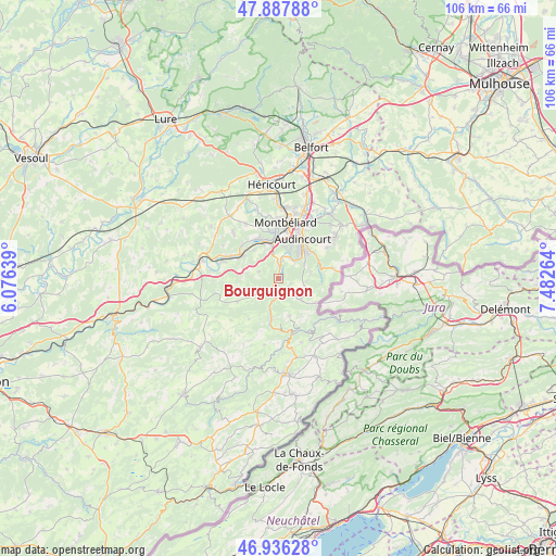
Bourguignon GPS coordinates[2]
47° 24' 51.228" North, 6° 46' 46.272" East
| Map corner | latitude | longitude |
|---|---|---|
| Upper-left | 47.88788°, | 6.07639° |
| Center: | 47.41423°, | 6.77952° |
| Lower-right: | 46.93628°, | 7.48264° |
| Map W x H: | 105.8×105.8 km | = 65.7×65.7mi |
| max Lat: | 51.07786° ⇑49.9% North |
| Bourguignon: | 47.41423° |
| min Lat: | ⇓50.1% South 41.3874° |
| min Long | Bourguignon | max Long |
| -5.08615° | 6.77952° | 9.52242° |
| W 93.5%⇐ | ⇒6.5% E |
Elevation
Elevation of Bourguignon is 342 m = 1122 ft, and this is 148.3 m = 487 ft above average elevation for this country.
| Max E: |
2333 m = 7654 ft | 15.3% |
| Bourguignon | 342 m 1122 ft | |
| Avg. | 193.7 m = 635 ft | |
Min E: |
-1 m = -3 ft | 84.7% |
See also: France elevation on elevation.city.
Geographical zone
Bourguignon is located in North temperate zone (between Tropic of Cancer and the Arctic Circle). Distance of this North polar circle is 2129.2 km =1323 mi to North.| Distance of | km | miles | from Bourguignon |
|---|---|---|---|
| North Pole | 4735.1 | 2942.3 | to North |
| Arctic Circle | 2129.2 | 1323 | to North |
| Tropic Cancer | 2666 | 1656.6 | to South |
| Equator | 5272 | 3275.9 | to South |


Nearby cities:
15 places around Bourguignon: (largest is in red/bold)
• Autechaux-Roide
3.6 km =2.2 mi,  133°
133°
• Bart
8.3 km =5.2 mi,  355°
355°
• Blamont
6.1 km =3.8 mi,  122°
122°
• Colombier-Fontaine
7.9 km =4.9 mi,  302°
302°
• Dampierre-sur-le-Doubs
7.6 km =4.7 mi,  331°
331°
• Hérimoncourt
8.4 km =5.2 mi,  67°
67°
• Mandeure
4.4 km =2.7 mi,  28°
28°
• Mathay
2.8 km =1.7 mi,  8°
8°
• Montécheroux
7.5 km =4.7 mi,  164°
164°
• Pont-de-Roide
3.1 km =1.9 mi,  195°
195°
• Roches-lès-Blamont
5.3 km =3.3 mi,  97°
97°
• Seloncourt
7.6 km =4.7 mi,  48°
48°
• Valentigney
6.8 km =4.2 mi,  35°
35°
• Voujeaucourt
6.8 km =4.2 mi, 356°
• Étouvans
7.2 km =4.5 mi,  321°
321°
Sources, notices
• [Note1] Compared only with cities in France existing in our database
• [Src1] Map data: © OpenStreetMap contributors (CC-BY-SA)
• [Src2] Other city data from geonames.org with taken over terms of usage.
• [Src3] Geographical zone / Annual Mean Temperature by Robert A. Rohde @ Wikipedia
