Pontcharra geodata
Pontcharra (Auvergne-Rhône-Alpes) is a populated place; located in France in Europe/Paris (GMT+2) time zone. With population of 6,948 people, there are 1422 cities with bigger population in this country. Compared to other cities in France, 74.8% of cities are located further ↑North; 87.2% of cities are located further ←West and 76.7% of cities have lower elevation than Pontcharra. Note1
Administrative division(s):
- Level 1: Auvergne-Rhône-Alpes
- Level 2: Département de l'Isère
- Level 3: Arrondissement de Grenoble
- Level 4: Pontcharra


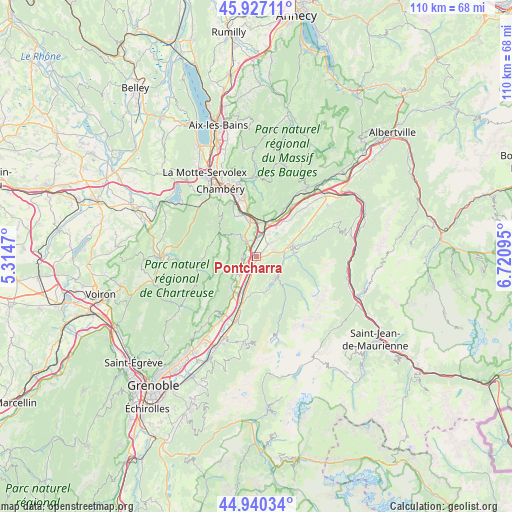
Pontcharra GPS coordinates[2]
45° 26' 9.168" North, 6° 1' 4.152" East
| Map corner | latitude | longitude |
|---|---|---|
| Upper-left | 45.92711°, | 5.3147° |
| Center: | 45.43588°, | 6.01782° |
| Lower-right: | 44.94034°, | 6.72095° |
| Map W x H: | 109.7×109.7 km | = 68.2×68.2mi |
| max Lat: | 51.07786° ⇑74.8% North |
| Pontcharra: | 45.43588° |
| min Lat: | ⇓25.2% South 41.3874° |
| min Long | Pontcharra | max Long |
| -5.08615° | 6.01782° | 9.52242° |
| W 87.2%⇐ | ⇒12.8% E |
Elevation
Elevation of Pontcharra is 261 m = 856 ft, and this is 67.3 m = 221 ft above average elevation for this country.
| Max E: |
2333 m = 7654 ft | 23.3% |
| Pontcharra | 261 m 856 ft | |
| Avg. | 193.7 m = 635 ft | |
Min E: |
-1 m = -3 ft | 76.7% |
See also: France elevation on elevation.city.
Geographical zone
Pontcharra is located in North temperate zone (between Tropic of Cancer and the Arctic Circle). Distance of this North polar circle is 2349.2 km =1459.7 mi to North.| Distance of | km | miles | from Pontcharra |
|---|---|---|---|
| North Pole | 4955.1 | 3079 | to North |
| Arctic Circle | 2349.2 | 1459.7 | to North |
| Tropic Cancer | 2446.1 | 1519.9 | to South |
| Equator | 5052 | 3139.2 | to South |


Nearby cities:
15 places around Pontcharra: (largest is in red/bold)
• Allevard
6.4 km =4 mi,  135°
135°
• Arvillard
7.9 km =4.9 mi,  84°
84°
• Barraux
3 km =1.9 mi,  261°
261°
• Chapareillan
3.8 km =2.4 mi,  327°
327°
• Francin
7.2 km =4.5 mi,  10°
10°
• La Buissière
4.8 km =3 mi,  214°
214°
• La Rochette
7.8 km =4.8 mi,  72°
72°
• Laissaud
2.1 km =1.3 mi,  51°
51°
• Le Cheylas
7.5 km =4.7 mi,  195°
195°
• Les Marches
7.3 km =4.5 mi,  351°
351°
• Les Mollettes
4.4 km =2.7 mi, 46°
• Montmélian
8.3 km =5.2 mi,  21°
21°
• Saint-Maximin
2.1 km =1.3 mi, 143°
• Saint-Vincent-de-Mercuze
8.7 km =5.4 mi,  215°
215°
• Sainte-Hélène-du-Lac
6.4 km =4 mi,  35°
35°
Sources, notices
• [Note1] Compared only with cities in France existing in our database
• [Src1] Map data: © OpenStreetMap contributors (CC-BY-SA)
• [Src2] Other city data from geonames.org with taken over terms of usage.
• [Src3] Geographical zone / Annual Mean Temperature by Robert A. Rohde @ Wikipedia
