Sainte-Hélène-du-Lac geodata
Sainte-Hélène-du-Lac (Auvergne-Rhône-Alpes) is a populated place; located in France in Europe/Paris (GMT+2) time zone. With population of 648 people, there are 12550 cities with bigger population in this country. Compared to other cities in France, 74.3% of cities are located further ↑North; 87.8% of cities are located further ←West and 77.8% of cities have lower elevation than Sainte-Hélène-du-Lac. Note1
Administrative division(s):
- Level 1: Auvergne-Rhône-Alpes
- Level 2: Savoie
- Level 3: Arrondissement de Chambéry
- Level 4: Sainte-Hélène-du-Lac


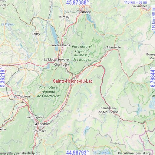
Sainte-Hélène-du-Lac GPS coordinates[2]
45° 28' 59.016" North, 6° 3' 55.152" East
| Map corner | latitude | longitude |
|---|---|---|
| Upper-left | 45.97388°, | 5.36219° |
| Center: | 45.48306°, | 6.06532° |
| Lower-right: | 44.98793°, | 6.76844° |
| Map W x H: | 109.6×109.6 km | = 68.1×68.1mi |
| max Lat: | 51.07786° ⇑74.3% North |
| Sainte-Hélène-du-Lac: | 45.48306° |
| min Lat: | ⇓25.7% South 41.3874° |
| min Long | Sainte-Hélène | max Long |
| -5.08615° | 6.06532° | 9.52242° |
| W 87.8%⇐ | ⇒12.2% E |
Elevation
Elevation of Sainte-Hélène-du-Lac is 270 m = 886 ft, and this is 76.3 m = 250 ft above average elevation for this country.
| Max E: |
2333 m = 7654 ft | 22.2% |
| Sainte-Hélène-du-Lac | 270 m 886 ft | |
| Avg. | 193.7 m = 635 ft | |
Min E: |
-1 m = -3 ft | 77.8% |
See also: France elevation on elevation.city.
Geographical zone
Sainte-Hélène-du-Lac is located in North temperate zone (between Tropic of Cancer and the Arctic Circle). Distance of this North polar circle is 2343.9 km =1456.4 mi to North.| Distance of | km | miles | from Sainte-Hélène-du-Lac |
|---|---|---|---|
| North Pole | 4949.8 | 3075.7 | to North |
| Arctic Circle | 2343.9 | 1456.4 | to North |
| Tropic Cancer | 2451.3 | 1523.2 | to South |
| Equator | 5057.2 | 3142.4 | to South |


Nearby cities:
15 places around Sainte-Hélène-du-Lac: (largest is in red/bold)
• Arbin
3.2 km =2 mi,  7°
7°
• Arvillard
6.1 km =3.8 mi,  137°
137°
• Chapareillan
6.1 km =3.8 mi,  250°
250°
• Chignin
6.1 km =3.8 mi,  317°
317°
• Cruet
5.5 km =3.4 mi,  22°
22°
• Francin
3.1 km =1.9 mi,  306°
306°
• La Rochette
4.7 km =2.9 mi,  126°
126°
• Laissaud
4.4 km =2.7 mi,  207°
207°
• Les Marches
5.2 km =3.2 mi,  291°
291°
• Les Mollettes
2.3 km =1.4 mi,  193°
193°
• Montmélian
2.5 km =1.6 mi,  344°
344°
• Myans
6.5 km =4 mi,  301°
301°
• Pontcharra
6.4 km =4 mi,  215°
215°
• Saint-Jeoire-Prieuré
7.8 km =4.8 mi, 311°
• Saint-Maximin
7.3 km =4.5 mi,  199°
199°
Sources, notices
• [Note1] Compared only with cities in France existing in our database
• [Src1] Map data: © OpenStreetMap contributors (CC-BY-SA)
• [Src2] Other city data from geonames.org with taken over terms of usage.
• [Src3] Geographical zone / Annual Mean Temperature by Robert A. Rohde @ Wikipedia
