Chapareillan geodata
Chapareillan (Auvergne-Rhône-Alpes) is a populated place; located in France in Europe/Paris (GMT+2) time zone. With population of 2,329 people, there are 4147 cities with bigger population in this country. Compared to other cities in France, 74.5% of cities are located further ↑North; 87% of cities are located further ←West and 79.4% of cities have lower elevation than Chapareillan. Note1
Administrative division(s):
- Level 1: Auvergne-Rhône-Alpes
- Level 2: Département de l'Isère
- Level 3: Arrondissement de Grenoble
- Level 4: Chapareillan


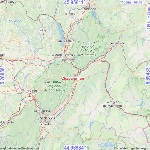
Chapareillan GPS coordinates[2]
45° 27' 54.468" North, 5° 59' 30.156" East
| Map corner | latitude | longitude |
|---|---|---|
| Upper-left | 45.95611°, | 5.28858° |
| Center: | 45.46513°, | 5.99171° |
| Lower-right: | 44.96984°, | 6.69483° |
| Map W x H: | 109.7×109.7 km | = 68.2×68.2mi |
| max Lat: | 51.07786° ⇑74.5% North |
| Chapareillan: | 45.46513° |
| min Lat: | ⇓25.5% South 41.3874° |
| min Long | Chapareillan | max Long |
| -5.08615° | 5.99171° | 9.52242° |
| W 87%⇐ | ⇒13% E |
Elevation
Elevation of Chapareillan is 284 m = 932 ft, and this is 90.3 m = 296 ft above average elevation for this country.
| Max E: |
2333 m = 7654 ft | 20.6% |
| Chapareillan | 284 m 932 ft | |
| Avg. | 193.7 m = 635 ft | |
Min E: |
-1 m = -3 ft | 79.4% |
See also: France elevation on elevation.city.
Geographical zone
Chapareillan is located in North temperate zone (between Tropic of Cancer and the Arctic Circle). Distance of this North polar circle is 2345.9 km =1457.7 mi to North.| Distance of | km | miles | from Chapareillan |
|---|---|---|---|
| North Pole | 4951.8 | 3076.9 | to North |
| Arctic Circle | 2345.9 | 1457.7 | to North |
| Tropic Cancer | 2449.3 | 1521.9 | to South |
| Equator | 5055.2 | 3141.2 | to South |


Nearby cities:
15 places around Chapareillan: (largest is in red/bold)
• Apremont
5.1 km =3.2 mi,  320°
320°
• Barraux
3.8 km =2.4 mi,  194°
194°
• Chignin
6.7 km =4.2 mi,  13°
13°
• Francin
5 km =3.1 mi,  40°
40°
• La Buissière
7.3 km =4.5 mi, 185°
• Laissaud
4.2 km =2.6 mi,  117°
117°
• Les Marches
4 km =2.5 mi, 13°
• Les Mollettes
5.2 km =3.2 mi,  92°
92°
• Montmélian
6.7 km =4.2 mi,  48°
48°
• Myans
5.4 km =3.4 mi,  1°
1°
• Pontcharra
3.8 km =2.4 mi,  147°
147°
• Saint-Baldoph
8 km =5 mi,  337°
337°
• Saint-Jeoire-Prieuré
7.2 km =4.5 mi,  358°
358°
• Saint-Maximin
5.9 km =3.7 mi, 146°
• Sainte-Hélène-du-Lac
6.1 km =3.8 mi,  70°
70°
Sources, notices
• [Note1] Compared only with cities in France existing in our database
• [Src1] Map data: © OpenStreetMap contributors (CC-BY-SA)
• [Src2] Other city data from geonames.org with taken over terms of usage.
• [Src3] Geographical zone / Annual Mean Temperature by Robert A. Rohde @ Wikipedia
