Barraux geodata
Barraux (Auvergne-Rhône-Alpes) is a populated place; located in France in Europe/Paris (GMT+2) time zone. With population of 1,585 people, there are 5888 cities with bigger population in this country. Compared to other cities in France, 74.9% of cities are located further ↑North; 86.8% of cities are located further ←West and 79.2% of cities have lower elevation than Barraux. Note1
Administrative division(s):
- Level 1: Auvergne-Rhône-Alpes
- Level 2: Département de l'Isère
- Level 3: Arrondissement de Grenoble
- Level 4: Barraux


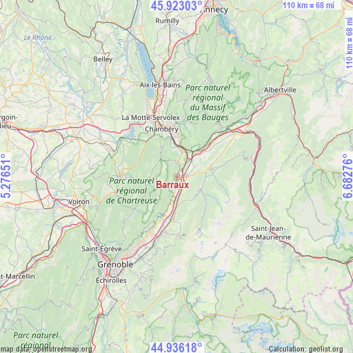
Barraux GPS coordinates[2]
45° 25' 54.336" North, 5° 58' 46.704" East
| Map corner | latitude | longitude |
|---|---|---|
| Upper-left | 45.92303°, | 5.27651° |
| Center: | 45.43176°, | 5.97964° |
| Lower-right: | 44.93618°, | 6.68276° |
| Map W x H: | 109.7×109.7 km | = 68.2×68.2mi |
| max Lat: | 51.07786° ⇑74.9% North |
| Barraux: | 45.43176° |
| min Lat: | ⇓25.1% South 41.3874° |
| min Long | Barraux | max Long |
| -5.08615° | 5.97964° | 9.52242° |
| W 86.8%⇐ | ⇒13.2% E |
Elevation
Elevation of Barraux is 282 m = 925 ft, and this is 88.3 m = 290 ft above average elevation for this country.
| Max E: |
2333 m = 7654 ft | 20.8% |
| Barraux | 282 m 925 ft | |
| Avg. | 193.7 m = 635 ft | |
Min E: |
-1 m = -3 ft | 79.2% |
See also: France elevation on elevation.city.
Geographical zone
Barraux is located in North temperate zone (between Tropic of Cancer and the Arctic Circle). Distance of this North polar circle is 2349.6 km =1460 mi to North.| Distance of | km | miles | from Barraux |
|---|---|---|---|
| North Pole | 4955.5 | 3079.2 | to North |
| Arctic Circle | 2349.6 | 1460 | to North |
| Tropic Cancer | 2445.6 | 1519.6 | to South |
| Equator | 5051.5 | 3138.9 | to South |


Nearby cities:
15 places around Barraux: (largest is in red/bold)
• Allevard
8.5 km =5.3 mi,  119°
119°
• Apremont
7.9 km =4.9 mi,  343°
343°
• Chapareillan
3.8 km =2.4 mi,  14°
14°
• Entremont-le-Vieux
7.5 km =4.7 mi,  271°
271°
• Francin
8.6 km =5.3 mi,  29°
29°
• La Buissière
3.5 km =2.2 mi,  175°
175°
• Laissaud
5 km =3.1 mi,  69°
69°
• Le Cheylas
6.9 km =4.3 mi,  171°
171°
• Le Touvet
8.3 km =5.2 mi,  194°
194°
• Les Marches
7.9 km =4.9 mi, 13°
• Les Mollettes
7.1 km =4.4 mi,  60°
60°
• Pontcharra
3 km =1.9 mi,  81°
81°
• Saint-Maximin
4.4 km =2.7 mi,  105°
105°
• Saint-Vincent-de-Mercuze
6.9 km =4.3 mi,  196°
196°
• Sainte-Hélène-du-Lac
8.8 km =5.5 mi,  49°
49°
Sources, notices
• [Note1] Compared only with cities in France existing in our database
• [Src1] Map data: © OpenStreetMap contributors (CC-BY-SA)
• [Src2] Other city data from geonames.org with taken over terms of usage.
• [Src3] Geographical zone / Annual Mean Temperature by Robert A. Rohde @ Wikipedia
