Baud geodata
Baud (Brittany) is a populated place; located in France in Europe/Paris (GMT+2) time zone. With population of 5,206 people, there are 1892 cities with bigger population in this country. Compared to other cities in France, 57.1% of cities are located further ↓South; 97.4% of cities are located further →East and 73.6% of cities have higher elevation than Baud. Note1
Administrative division(s):
- Level 1: Brittany
- Level 2: Morbihan
- Level 3: Arrondissement de Pontivy
- Level 4: Baud


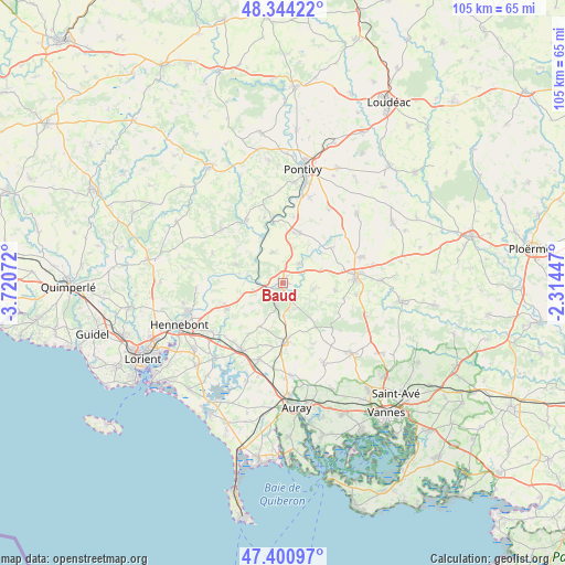
Baud GPS coordinates[2]
47° 52' 29.064" North, 3° 1' 3.36" West
| Map corner | latitude | longitude |
|---|---|---|
| Upper-left | 48.34422°, | -3.72072° |
| Center: | 47.87474°, | -3.0176° |
| Lower-right: | 47.40097°, | -2.31447° |
| Map W x H: | 104.9×104.9 km | = 65.2×65.2mi |
| max Lat: | 51.07786° ⇑42.9% North |
| Baud: | 47.87474° |
| min Lat: | ⇓57.1% South 41.3874° |
| min Long | Baud | max Long |
| -5.08615° | -3.0176° | 9.52242° |
| W 2.6%⇐ | ⇒97.4% E |
Elevation
Elevation of Baud is 70 m = 230 ft, and this is 123.7 m = 406 ft below average elevation for this country.
| Max E: |
2333 m = 7654 ft | 73.6% |
| Avg. | 193.7 m = 635 ft | |
| Baud | 70 m = 230 ft | |
Min E: |
-1 m = -3 ft | 26.4% |
See also: France elevation on elevation.city.
Geographical zone
Baud is located in North temperate zone (between Tropic of Cancer and the Arctic Circle). Distance of this North polar circle is 2078 km =1291.2 mi to North.| Distance of | km | miles | from Baud |
|---|---|---|---|
| North Pole | 4683.9 | 2910.4 | to North |
| Arctic Circle | 2078 | 1291.2 | to North |
| Tropic Cancer | 2717.3 | 1688.5 | to South |
| Equator | 5323.2 | 3307.7 | to South |


Nearby cities:
15 places around Baud: (largest is in red/bold)
• Bieuzy
12.6 km =7.8 mi,  343°
343°
• Brandivy
12.6 km =7.8 mi,  154°
154°
• Camors
3.3 km =2.1 mi,  156°
156°
• Guénin
4.6 km =2.9 mi,  37°
37°
• La Chapelle-Neuve
5.9 km =3.7 mi,  101°
101°
• Languidic
11.5 km =7.1 mi,  245°
245°
• Locminé
13.6 km =8.5 mi,  84°
84°
• Melrand
13.6 km =8.5 mi,  329°
329°
• Moustoir-Ac
13.8 km =8.6 mi, 99°
• Plumelin
9.8 km =6.1 mi, 99°
• Pluméliau
9.8 km =6.1 mi,  19°
19°
• Pluvigner
11 km =6.8 mi,  177°
177°
• Quistinic
9.3 km =5.8 mi,  290°
290°
• Remungol
11.1 km =6.9 mi,  54°
54°
• Saint-Allouestre
11 km =6.8 mi,  65°
65°
Sources, notices
• [Note1] Compared only with cities in France existing in our database
• [Src1] Map data: © OpenStreetMap contributors (CC-BY-SA)
• [Src2] Other city data from geonames.org with taken over terms of usage.
• [Src3] Geographical zone / Annual Mean Temperature by Robert A. Rohde @ Wikipedia
