Ploudiry geodata
Ploudiry (Brittany) is a populated place; located in France in Europe/Paris (GMT+2) time zone. With population of 859 people, there are 9999 cities with bigger population in this country. Compared to other cities in France, 67.2% of cities are located further ↓South; 99.2% of cities are located further →East and 62.5% of cities have lower elevation than Ploudiry. Note1
Administrative division(s):
- Level 1: Brittany
- Level 2: Département du Finistère
- Level 3: Arrondissement de Brest
- Level 4: Ploudiry


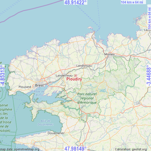
Ploudiry GPS coordinates[2]
48° 27' 0" North, 4° 9' 0" West
| Map corner | latitude | longitude |
|---|---|---|
| Upper-left | 48.91422°, | -4.85313° |
| Center: | 48.45°, | -4.15° |
| Lower-right: | 47.98149°, | -3.44688° |
| Map W x H: | 103.7×103.7 km | = 64.4×64.4mi |
| max Lat: | 51.07786° ⇑32.8% North |
| Ploudiry: | 48.45° |
| min Lat: | ⇓67.2% South 41.3874° |
| min Long | Ploudiry | max Long |
| -5.08615° | -4.15° | 9.52242° |
| W 0.8%⇐ | ⇒99.2% E |
Elevation
Elevation of Ploudiry is 182 m = 597 ft, and this is 11.7 m = 38 ft below average elevation for this country.
| Max E: |
2333 m = 7654 ft | 37.5% |
| Avg. | 193.7 m = 635 ft | |
| Ploudiry | 182 m = 597 ft | |
Min E: |
-1 m = -3 ft | 62.5% |
See also: France elevation on elevation.city.
Geographical zone
Ploudiry is located in North temperate zone (between Tropic of Cancer and the Arctic Circle). Distance of this North polar circle is 2014 km =1251.4 mi to North.| Distance of | km | miles | from Ploudiry |
|---|---|---|---|
| North Pole | 4619.9 | 2870.7 | to North |
| Arctic Circle | 2014 | 1251.4 | to North |
| Tropic Cancer | 2781.2 | 1728.2 | to South |
| Equator | 5387.1 | 3347.4 | to South |


Nearby cities:
15 places around Ploudiry: (largest is in red/bold)
• Bodilis
9.2 km =5.7 mi,  15°
15°
• Dirinon
10.6 km =6.6 mi,  236°
236°
• Irvillac
10 km =6.2 mi,  207°
207°
• La Martyre
0.7 km =0.4 mi,  257°
257°
• La Roche-Maurice
4.7 km =2.9 mi,  305°
305°
• Lampaul-Guimiliau
9.2 km =5.7 mi,  59°
59°
• Landerneau
7.6 km =4.7 mi,  272°
272°
• Landivisiau
8.8 km =5.5 mi,  43°
43°
• Pencran
6.4 km =4 mi,  253°
253°
• Plounéventer
8.9 km =5.5 mi,  326°
326°
• Plouédern
8.3 km =5.2 mi,  296°
296°
• Saint-Sauveur
11.1 km =6.9 mi,  90°
90°
• Saint-Servais
7.4 km =4.6 mi,  0°
0°
• Saint-Urbain
8.3 km =5.2 mi,  227°
227°
• Sizun
7.4 km =4.6 mi,  138°
138°
Sources, notices
• [Note1] Compared only with cities in France existing in our database
• [Src1] Map data: © OpenStreetMap contributors (CC-BY-SA)
• [Src2] Other city data from geonames.org with taken over terms of usage.
• [Src3] Geographical zone / Annual Mean Temperature by Robert A. Rohde @ Wikipedia
