Irvillac geodata
Irvillac (Brittany) is a populated place; located in France in Europe/Paris (GMT+2) time zone. With population of 1,064 people, there are 8375 cities with bigger population in this country. Compared to other cities in France, 65.9% of cities are located further ↓South; 99.3% of cities are located further →East and 60.8% of cities have higher elevation than Irvillac. Note1
Administrative division(s):
- Level 1: Brittany
- Level 2: Département du Finistère
- Level 3: Arrondissement de Brest
- Level 4: Irvillac


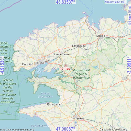
Irvillac GPS coordinates[2]
48° 22' 12.396" North, 4° 12' 44.028" West
| Map corner | latitude | longitude |
|---|---|---|
| Upper-left | 48.83507°, | -4.91536° |
| Center: | 48.37011°, | -4.21223° |
| Lower-right: | 47.90087°, | -3.50911° |
| Map W x H: | 103.9×103.9 km | = 64.6×64.6mi |
| max Lat: | 51.07786° ⇑34.1% North |
| Irvillac: | 48.37011° |
| min Lat: | ⇓65.9% South 41.3874° |
| min Long | Irvillac | max Long |
| -5.08615° | -4.21223° | 9.52242° |
| W 0.7%⇐ | ⇒99.3% E |
Elevation
Elevation of Irvillac is 100 m = 328 ft, and this is 93.7 m = 307 ft below average elevation for this country.
| Max E: |
2333 m = 7654 ft | 60.8% |
| Avg. | 193.7 m = 635 ft | |
| Irvillac | 100 m = 328 ft | |
Min E: |
-1 m = -3 ft | 39.2% |
See also: France elevation on elevation.city.
Geographical zone
Irvillac is located in North temperate zone (between Tropic of Cancer and the Arctic Circle). Distance of this North polar circle is 2022.9 km =1257 mi to North.| Distance of | km | miles | from Irvillac |
|---|---|---|---|
| North Pole | 4628.8 | 2876.2 | to North |
| Arctic Circle | 2022.9 | 1257 | to North |
| Tropic Cancer | 2772.3 | 1722.6 | to South |
| Equator | 5378.3 | 3341.9 | to South |


Nearby cities:
15 places around Irvillac: (largest is in red/bold)
• Daoulas
3.7 km =2.3 mi,  253°
253°
• Dirinon
5.3 km =3.3 mi,  305°
305°
• Hanvec
6.2 km =3.9 mi,  140°
140°
• Hôpital-Camfrout
5.2 km =3.2 mi,  204°
204°
• La Forest-Landerneau
9.8 km =6.1 mi, 309°
• La Martyre
9.6 km =6 mi,  24°
24°
• Landerneau
9.6 km =6 mi,  342°
342°
• Le Faou
8.7 km =5.4 mi,  163°
163°
• Logonna-Daoulas
8.1 km =5 mi,  230°
230°
• Loperhet
7 km =4.3 mi,  276°
276°
• Pencran
7.2 km =4.5 mi,  347°
347°
• Ploudiry
10 km =6.2 mi,  27°
27°
• Plougastel-Daoulas
11.4 km =7.1 mi,  268°
268°
• Saint-Urbain
3.7 km =2.3 mi,  334°
334°
• Sizun
10.1 km =6.3 mi,  70°
70°
Sources, notices
• [Note1] Compared only with cities in France existing in our database
• [Src1] Map data: © OpenStreetMap contributors (CC-BY-SA)
• [Src2] Other city data from geonames.org with taken over terms of usage.
• [Src3] Geographical zone / Annual Mean Temperature by Robert A. Rohde @ Wikipedia
