Perthes geodata
Perthes (Grand Est) is a populated place; located in France in Europe/Paris (GMT+2) time zone. With population of 612 people, there are 13126 cities with bigger population in this country. Compared to other cities in France, 72.2% of cities are located further ↓South; 75.4% of cities are located further ←West and 51.4% of cities have higher elevation than Perthes. Note1
Administrative division(s):
- Level 1: Grand Est
- Level 2: Haute-Marne
- Level 3: Arrondissement de Saint-Dizier
- Level 4: Perthes


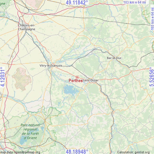
Perthes GPS coordinates[2]
48° 39' 21.924" North, 4° 49' 24.348" East
| Map corner | latitude | longitude |
|---|---|---|
| Upper-left | 49.11842°, | 4.12031° |
| Center: | 48.65609°, | 4.82343° |
| Lower-right: | 48.18948°, | 5.52656° |
| Map W x H: | 103.3×103.3 km | = 64.2×64.2mi |
| max Lat: | 51.07786° ⇑27.8% North |
| Perthes: | 48.65609° |
| min Lat: | ⇓72.2% South 41.3874° |
| min Long | Perthes | max Long |
| -5.08615° | 4.82343° | 9.52242° |
| W 75.4%⇐ | ⇒24.6% E |
Elevation
Elevation of Perthes is 127 m = 417 ft, and this is 66.7 m = 219 ft below average elevation for this country.
| Max E: |
2333 m = 7654 ft | 51.4% |
| Avg. | 193.7 m = 635 ft | |
| Perthes | 127 m = 417 ft | |
Min E: |
-1 m = -3 ft | 48.6% |
See also: France elevation on elevation.city.
Geographical zone
Perthes is located in North temperate zone (between Tropic of Cancer and the Arctic Circle). Distance of this North polar circle is 1991.1 km =1237.2 mi to North.| Distance of | km | miles | from Perthes |
|---|---|---|---|
| North Pole | 4597 | 2856.4 | to North |
| Arctic Circle | 1991.1 | 1237.2 | to North |
| Tropic Cancer | 2804.1 | 1742.4 | to South |
| Equator | 5410.1 | 3361.7 | to South |


Nearby cities:
15 places around Perthes: (largest is in red/bold)
• Ancerville
14.7 km =9.1 mi,  98°
98°
• Bettancourt-la-Ferrée
10.8 km =6.7 mi,  94°
94°
• Chancenay
12.1 km =7.5 mi,  82°
82°
• Cheminon
10.9 km =6.8 mi,  33°
33°
• Humbécourt
10 km =6.2 mi,  144°
144°
• Louvemont
13.2 km =8.2 mi,  150°
150°
• Maurupt-le-Montois
10.7 km =6.6 mi,  10°
10°
• Moëslains
6.7 km =4.2 mi,  127°
127°
• Pargny-sur-Saulx
12.6 km =7.8 mi,  4°
4°
• Saint-Dizier
9.4 km =5.8 mi, 102°
• Saint-Remy-en-Bouzemont-Saint-Genest-et-Isson
13 km =8.1 mi,  258°
258°
• Sermaize-les-Bains
15.7 km =9.8 mi,  24°
24°
• Thiéblemont-Farémont
7.8 km =4.8 mi,  298°
298°
• Valcourt
7.5 km =4.7 mi, 125°
• Villiers-en-Lieu
5.6 km =3.5 mi, 76°
Sources, notices
• [Note1] Compared only with cities in France existing in our database
• [Src1] Map data: © OpenStreetMap contributors (CC-BY-SA)
• [Src2] Other city data from geonames.org with taken over terms of usage.
• [Src3] Geographical zone / Annual Mean Temperature by Robert A. Rohde @ Wikipedia
