Villiers-en-Lieu geodata
Villiers-en-Lieu (Grand Est) is a populated place; located in France in Europe/Paris (GMT+2) time zone. With population of 1,448 people, there are 6395 cities with bigger population in this country. Compared to other cities in France, 72.4% of cities are located further ↓South; 76.4% of cities are located further ←West and 53.6% of cities have lower elevation than Villiers-en-Lieu. Note1
Administrative division(s):
- Level 1: Grand Est
- Level 2: Haute-Marne
- Level 3: Arrondissement de Saint-Dizier
- Level 4: Villiers-en-Lieu


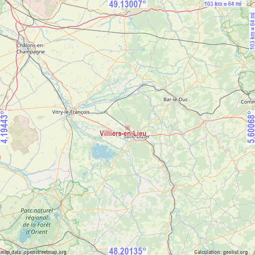
Villiers-en-Lieu GPS coordinates[2]
48° 40' 4.26" North, 4° 53' 51.18" East
| Map corner | latitude | longitude |
|---|---|---|
| Upper-left | 49.13007°, | 4.19443° |
| Center: | 48.66785°, | 4.89755° |
| Lower-right: | 48.20135°, | 5.60068° |
| Map W x H: | 103.3×103.3 km | = 64.2×64.2mi |
| max Lat: | 51.07786° ⇑27.6% North |
| Villiers-en-Lieu: | 48.66785° |
| min Lat: | ⇓72.4% South 41.3874° |
| min Long | Villiers-en-Lie | max Long |
| -5.08615° | 4.89755° | 9.52242° |
| W 76.4%⇐ | ⇒23.6% E |
Elevation
Elevation of Villiers-en-Lieu is 145 m = 476 ft, and this is 48.7 m = 160 ft below average elevation for this country.
| Max E: |
2333 m = 7654 ft | 46.4% |
| Avg. | 193.7 m = 635 ft | |
| Villiers-en-Lieu | 145 m = 476 ft | |
Min E: |
-1 m = -3 ft | 53.6% |
See also: France elevation on elevation.city.
Geographical zone
Villiers-en-Lieu is located in North temperate zone (between Tropic of Cancer and the Arctic Circle). Distance of this North polar circle is 1989.8 km =1236.4 mi to North.| Distance of | km | miles | from Villiers-en-Lieu |
|---|---|---|---|
| North Pole | 4595.7 | 2855.6 | to North |
| Arctic Circle | 1989.8 | 1236.4 | to North |
| Tropic Cancer | 2805.4 | 1743.2 | to South |
| Equator | 5411.4 | 3362.5 | to South |


Nearby cities:
15 places around Villiers-en-Lieu: (largest is in red/bold)
• Ancerville
9.7 km =6 mi,  111°
111°
• Bettancourt-la-Ferrée
5.7 km =3.5 mi, 111°
• Chancenay
6.6 km =4.1 mi,  87°
87°
• Cheminon
7.8 km =4.8 mi,  4°
4°
• Humbécourt
9.4 km =5.8 mi,  177°
177°
• Lisle-en-Rigault
12.3 km =7.6 mi,  63°
63°
• Maurupt-le-Montois
9.8 km =6.1 mi,  339°
339°
• Moëslains
5.3 km =3.3 mi, 181°
• Pargny-sur-Saulx
12 km =7.5 mi, 338°
• Perthes
5.6 km =3.5 mi,  256°
256°
• Roches-sur-Marne
12.7 km =7.9 mi,  123°
123°
• Saint-Dizier
5 km =3.1 mi,  131°
131°
• Sommelonne
10.2 km =6.3 mi, 87°
• Thiéblemont-Farémont
12.5 km =7.8 mi,  281°
281°
• Valcourt
5.7 km =3.5 mi,  172°
172°
Sources, notices
• [Note1] Compared only with cities in France existing in our database
• [Src1] Map data: © OpenStreetMap contributors (CC-BY-SA)
• [Src2] Other city data from geonames.org with taken over terms of usage.
• [Src3] Geographical zone / Annual Mean Temperature by Robert A. Rohde @ Wikipedia
