Perpignan geodata
Perpignan (Occitanie) is a seat of a second-order administrative division; located in France in Europe/Paris (GMT+2) time zone. With population of 110,706 people, there are 34 cities with bigger population in this country. Compared to other cities in France, 99% of cities are located further ↑North; 56.3% of cities are located further ←West and 84.5% of cities have higher elevation than Perpignan. Note1
Administrative division(s):
- Level 1: Occitanie
- Level 2: Département des Pyrénées-Orientales
- Level 3: Arrondissement de Perpignan
- Level 4: Perpignan


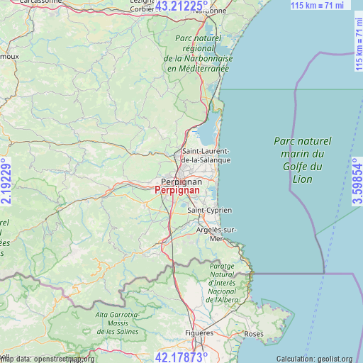
Perpignan GPS coordinates[2]
42° 41' 51.504" North, 2° 53' 43.476" East
| Map corner | latitude | longitude |
|---|---|---|
| Upper-left | 43.21225°, | 2.19229° |
| Center: | 42.69764°, | 2.89541° |
| Lower-right: | 42.17873°, | 3.59854° |
| Map W x H: | 114.9×114.9 km | = 71.4×71.4mi |
| max Lat: | 51.07786° ⇑99% North |
| Perpignan: | 42.69764° |
| min Lat: | ⇓1% South 41.3874° |
| min Long | Perpignan | max Long |
| -5.08615° | 2.89541° | 9.52242° |
| W 56.3%⇐ | ⇒43.7% E |
Elevation
Elevation of Perpignan is 43 m = 141 ft, and this is 150.7 m = 494 ft below average elevation for this country.
| Max E: |
2333 m = 7654 ft | 84.5% |
| Avg. | 193.7 m = 635 ft | |
| Perpignan | 43 m = 141 ft | |
Min E: |
-1 m = -3 ft | 15.5% |
See also: Perpignan elevation on elevation.city.
Geographical zone
Perpignan is located in North temperate zone (between Tropic of Cancer and the Arctic Circle). Distance of this Northern Tropic circle is 2141.6 km =1330.7 mi to South.| Distance of | km | miles | from Perpignan |
|---|---|---|---|
| North Pole | 5259.5 | 3268.1 | to North |
| Arctic Circle | 2653.6 | 1648.9 | to North |
| Tropic Cancer | 2141.6 | 1330.7 | to South |
| Equator | 4747.5 | 2950 | to South |


Nearby cities:
15 places around Perpignan: (largest is in red/bold)
• Baho
6 km =3.7 mi,  272°
272°
• Bompas
5 km =3.1 mi,  37°
37°
• Cabestany
4.2 km =2.6 mi,  115°
115°
• Canohès
6.8 km =4.2 mi,  225°
225°
• Peyrestortes
7.3 km =4.5 mi,  331°
331°
• Pia
5.6 km =3.5 mi,  20°
20°
• Pollestres
6.5 km =4 mi,  197°
197°
• Rivesaltes
8.2 km =5.1 mi,  346°
346°
• Saint-Estève
4.4 km =2.7 mi,  290°
290°
• Saleilles
6.8 km =4.2 mi,  135°
135°
• Théza
8 km =5 mi,  145°
145°
• Toulouges
6.2 km =3.9 mi,  239°
239°
• Villelongue-de-la-Salanque
7.8 km =4.8 mi,  65°
65°
• Villeneuve-de-la-Raho
7.1 km =4.4 mi,  165°
165°
• Villeneuve-la-Rivière
7.6 km =4.7 mi, 266°
In other languages:
- In Spanish: Perpiñán
- In Italian: Perpignano
- In Russian: Перпиньян
- In Chinese: 佩皮尼昂
Sources, notices
• [Note1] Compared only with cities in France existing in our database
• [Src1] Map data: © OpenStreetMap contributors (CC-BY-SA)
• [Src2] Other city data from geonames.org with taken over terms of usage.
• [Src3] Geographical zone / Annual Mean Temperature by Robert A. Rohde @ Wikipedia
