Rivesaltes geodata
Rivesaltes (Occitanie) is a populated place; located in France in Europe/Paris (GMT+2) time zone. With population of 8,836 people, there are 1088 cities with bigger population in this country. Compared to other cities in France, 98.8% of cities are located further ↑North; 56% of cities are located further ←West and 90.3% of cities have higher elevation than Rivesaltes. Note1
Administrative division(s):
- Level 1: Occitanie
- Level 2: Département des Pyrénées-Orientales
- Level 3: Arrondissement de Perpignan
- Level 4: Rivesaltes


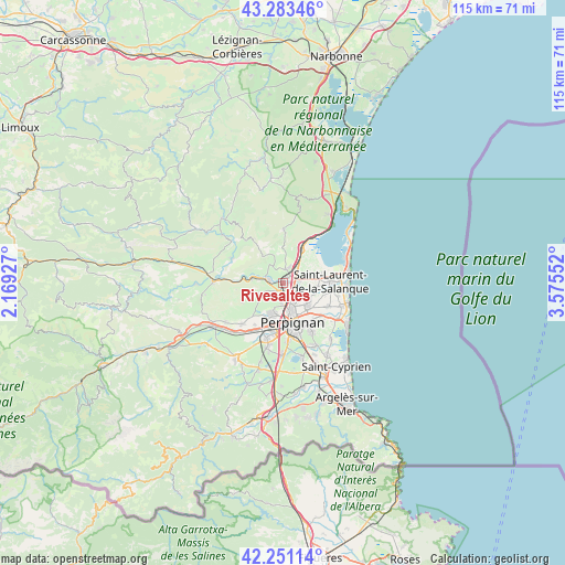
Rivesaltes GPS coordinates[2]
42° 46' 10.02" North, 2° 52' 20.604" East
| Map corner | latitude | longitude |
|---|---|---|
| Upper-left | 43.28346°, | 2.16927° |
| Center: | 42.76945°, | 2.87239° |
| Lower-right: | 42.25114°, | 3.57552° |
| Map W x H: | 114.8×114.8 km | = 71.3×71.3mi |
| max Lat: | 51.07786° ⇑98.8% North |
| Rivesaltes: | 42.76945° |
| min Lat: | ⇓1.2% South 41.3874° |
| min Long | Rivesaltes | max Long |
| -5.08615° | 2.87239° | 9.52242° |
| W 56%⇐ | ⇒44% E |
Elevation
Elevation of Rivesaltes is 29 m = 95 ft, and this is 164.7 m = 540 ft below average elevation for this country.
| Max E: |
2333 m = 7654 ft | 90.3% |
| Avg. | 193.7 m = 635 ft | |
| Rivesaltes | 29 m = 95 ft | |
Min E: |
-1 m = -3 ft | 9.7% |
See also: France elevation on elevation.city.
Geographical zone
Rivesaltes is located in North temperate zone (between Tropic of Cancer and the Arctic Circle). Distance of this Northern Tropic circle is 2149.6 km =1335.7 mi to South.| Distance of | km | miles | from Rivesaltes |
|---|---|---|---|
| North Pole | 5251.5 | 3263.1 | to North |
| Arctic Circle | 2645.7 | 1644 | to North |
| Tropic Cancer | 2149.6 | 1335.7 | to South |
| Equator | 4755.5 | 2954.9 | to South |


Nearby cities:
15 places around Rivesaltes: (largest is in red/bold)
• Baho
8.7 km =5.4 mi,  208°
208°
• Baixas
5.5 km =3.4 mi,  246°
246°
• Bompas
6.4 km =4 mi,  128°
128°
• Cases-de-Pène
7.1 km =4.4 mi,  277°
277°
• Claira
6.9 km =4.3 mi,  98°
98°
• Perpignan
8.2 km =5.1 mi,  166°
166°
• Peyrestortes
2.3 km =1.4 mi,  225°
225°
• Pia
4.7 km =2.9 mi, 125°
• Saint-Estève
6.8 km =4.2 mi,  199°
199°
• Saint-Hippolyte
7.9 km =4.9 mi,  76°
76°
• Saint-Laurent-de-la-Salanque
9.6 km =6 mi,  87°
87°
• Salses-le-Château
8 km =5 mi,  26°
26°
• Torreilles
10 km =6.2 mi, 99°
• Villelongue-de-la-Salanque
10.2 km =6.3 mi,  118°
118°
• Villeneuve-la-Rivière
10.2 km =6.3 mi, 213°
Sources, notices
• [Note1] Compared only with cities in France existing in our database
• [Src1] Map data: © OpenStreetMap contributors (CC-BY-SA)
• [Src2] Other city data from geonames.org with taken over terms of usage.
• [Src3] Geographical zone / Annual Mean Temperature by Robert A. Rohde @ Wikipedia
