Saint-Estève geodata
Saint-Estève (Occitanie) is a populated place; located in France in Europe/Paris (GMT+2) time zone. With population of 10,403 people, there are 913 cities with bigger population in this country. Compared to other cities in France, 99% of cities are located further ↑North; 55.6% of cities are located further ←West and 81.5% of cities have higher elevation than Saint-Estève. Note1
Administrative division(s):
- Level 1: Occitanie
- Level 2: Département des Pyrénées-Orientales
- Level 3: Arrondissement de Perpignan
- Level 4: Saint-Estève


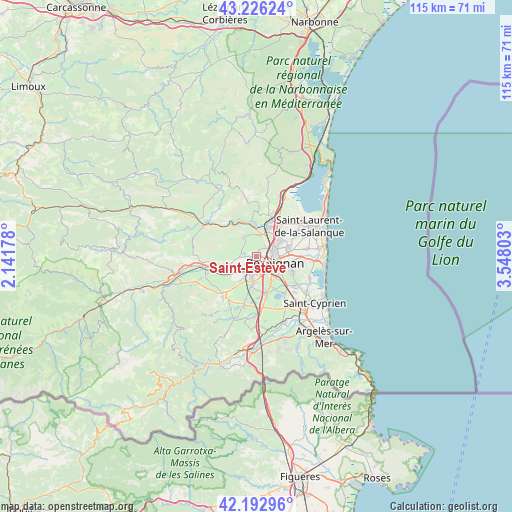
Saint-Estève GPS coordinates[2]
42° 42' 42.3" North, 2° 50' 41.64" East
| Map corner | latitude | longitude |
|---|---|---|
| Upper-left | 43.22624°, | 2.14178° |
| Center: | 42.71175°, | 2.8449° |
| Lower-right: | 42.19296°, | 3.54803° |
| Map W x H: | 114.9×114.9 km | = 71.4×71.4mi |
| max Lat: | 51.07786° ⇑99% North |
| Saint-Estève: | 42.71175° |
| min Lat: | ⇓1% South 41.3874° |
| min Long | Saint-Estève | max Long |
| -5.08615° | 2.8449° | 9.52242° |
| W 55.6%⇐ | ⇒44.4% E |
Elevation
Elevation of Saint-Estève is 51 m = 167 ft, and this is 142.7 m = 468 ft below average elevation for this country.
| Max E: |
2333 m = 7654 ft | 81.5% |
| Avg. | 193.7 m = 635 ft | |
| Saint-Estève | 51 m = 167 ft | |
Min E: |
-1 m = -3 ft | 18.5% |
See also: France elevation on elevation.city.
Geographical zone
Saint-Estève is located in North temperate zone (between Tropic of Cancer and the Arctic Circle). Distance of this Northern Tropic circle is 2143.2 km =1331.7 mi to South.| Distance of | km | miles | from Saint-Estève |
|---|---|---|---|
| North Pole | 5258 | 3267.2 | to North |
| Arctic Circle | 2652.1 | 1647.9 | to North |
| Tropic Cancer | 2143.2 | 1331.7 | to South |
| Equator | 4749.1 | 2951 | to South |


Nearby cities:
15 places around Saint-Estève: (largest is in red/bold)
• Baho
2.3 km =1.4 mi,  235°
235°
• Baixas
5.1 km =3.2 mi,  325°
325°
• Bompas
7.6 km =4.7 mi,  71°
71°
• Cabestany
8.6 km =5.3 mi,  113°
113°
• Canohès
6.4 km =4 mi,  186°
186°
• Cases-de-Pène
8.8 km =5.5 mi, 327°
• Le Soler
5.4 km =3.4 mi,  230°
230°
• Perpignan
4.4 km =2.7 mi, 110°
• Peyrestortes
4.8 km =3 mi,  7°
7°
• Pia
7.1 km =4.4 mi,  58°
58°
• Pollestres
8 km =5 mi,  164°
164°
• Pézilla-la-Rivière
6.3 km =3.9 mi,  253°
253°
• Rivesaltes
6.8 km =4.2 mi,  19°
19°
• Toulouges
4.8 km =3 mi, 194°
• Villeneuve-la-Rivière
4 km =2.5 mi, 239°
Sources, notices
• [Note1] Compared only with cities in France existing in our database
• [Src1] Map data: © OpenStreetMap contributors (CC-BY-SA)
• [Src2] Other city data from geonames.org with taken over terms of usage.
• [Src3] Geographical zone / Annual Mean Temperature by Robert A. Rohde @ Wikipedia
